Pine Beach, New Jersey facts for kids
Quick facts for kids
Pine Beach, New Jersey
|
||
|---|---|---|
|
Borough
|
||
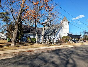
Pine Beach Chapel
|
||
|
||
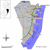
Map of Pine Beach in Ocean County. Inset: Location of Ocean County highlighted in the State of New Jersey.
|
||
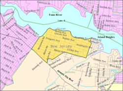
Census Bureau map of Pine Beach, New Jersey
|
||
| Country | ||
| state | ||
| County | ||
| Incorporated | February 26, 1925 | |
| Government | ||
| • Type | Borough | |
| • Body | Borough Council | |
| Area | ||
| • Total | 0.64 sq mi (1.66 km2) | |
| • Land | 0.64 sq mi (1.65 km2) | |
| • Water | 0.01 sq mi (0.01 km2) 0.78% | |
| Area rank | 533rd of 565 in state 31st of 33 in county |
|
| Elevation | 16 ft (5 m) | |
| Population
(2020)
|
||
| • Total | 2,139 | |
| • Estimate
(2023)
|
2,193 | |
| • Rank | 481st of 565 in state 21st of 33 in county |
|
| • Density | 3,362.1/sq mi (1,298.1/km2) | |
| • Density rank | 200th of 565 in state 6th of 33 in county |
|
| Time zone | UTC−05:00 (Eastern (EST)) | |
| • Summer (DST) | UTC−04:00 (Eastern (EDT)) | |
| ZIP Code |
08741
|
|
| Area code(s) | 732 | |
| FIPS code | 3402958590 | |
| GNIS feature ID | 0885351 | |
| Website | ||
Pine Beach is a small town, called a borough, located in Ocean County, New Jersey. It's a state in the United States. In 2020, about 2,139 people lived there. This was the most people ever counted in Pine Beach!
Pine Beach became an official borough on February 26, 1925. It was formed from parts of Berkeley Township.
Contents
About Pine Beach's Location
Pine Beach is a small area. The United States Census Bureau says it covers about 0.64 square miles (1.66 square kilometers). Most of this area is land, with a tiny bit of water.
This borough shares its borders with other towns in Ocean County. These include Beachwood and Berkeley Township. Pine Beach is also part of the Toms River watershed. This means its water flows into the Toms River.
People Living in Pine Beach
| Historical population | |||
|---|---|---|---|
| Census | Pop. | %± | |
| 1930 | 72 | — | |
| 1940 | 163 | 126.4% | |
| 1950 | 495 | 203.7% | |
| 1960 | 985 | 99.0% | |
| 1970 | 1,395 | 41.6% | |
| 1980 | 1,796 | 28.7% | |
| 1990 | 1,954 | 8.8% | |
| 2000 | 1,950 | −0.2% | |
| 2010 | 2,127 | 9.1% | |
| 2020 | 2,139 | 0.6% | |
| 2023 (est.) | 2,193 | 3.1% | |
| Population sources: 1930–2000 1930 1940–2000 2000 2010 2020 |
|||
Population Details from 2010
The 2010 United States census counted 2,127 people living in Pine Beach. There were 818 households, which are groups of people living together. Most of these (617) were families.
Most people in Pine Beach were White (96.47%). A small number were Asian (1.41%). About 3.71% of the population were Hispanic or Latino.
In these households, about 29.6% had children under 18. Many were married couples living together (59.9%). About 10.5% of homes had someone living alone who was 65 or older.
The average age of people in Pine Beach was 44.9 years. About 22.4% of the population was under 18.
Schools in Pine Beach
Students in Pine Beach go to public schools in the Toms River Regional Schools district. This district is based in Toms River Township. It also serves students from Beachwood and South Toms River.
The school district has three schools. In the 2020–2021 school year, there were 1,331 students. There was about one teacher for every nine students. Pine Beach has one representative on the school board.
A private school called Admiral Farragut Academy used to be in Pine Beach. It opened in 1933 but closed its Pine Beach campus in 1994. The school still operates in Florida.
Getting Around Pine Beach
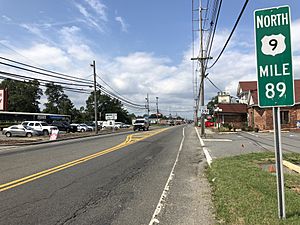
Pine Beach has many roads. As of 2010, there were about 15.22 miles of roads. Most of these roads are kept up by the borough itself.
One important road, U.S. Route 9, runs along the edge of Pine Beach. It borders Berkeley Township.
For public transportation, NJ Transit offers bus service. You can take the 559 bus route from Pine Beach to Atlantic City.
Famous People from Pine Beach
Some notable people have lived in or are connected to Pine Beach:
- U. E. Baughman (1905–1978) was the chief of the United States Secret Service. He worked for Presidents Truman, Eisenhower, and Kennedy.
- Monique Luiz (born 1961) is known for being in a famous TV ad. It was for Lyndon Johnson's 1964 presidential campaign. The ad was called "Daisy".
- Benjamin H. Mabie was a politician. He served in the New Jersey General Assembly and was also the mayor of Pine Beach.
- George Winterling (born 1931) was a TV weatherman. He created the heat index, which tells us how hot it feels.
See also
 In Spanish: Pine Beach para niños
 | Leon Lynch |
 | Milton P. Webster |
 | Ferdinand Smith |


