Piura River facts for kids
Quick facts for kids Piura River |
|
|---|---|

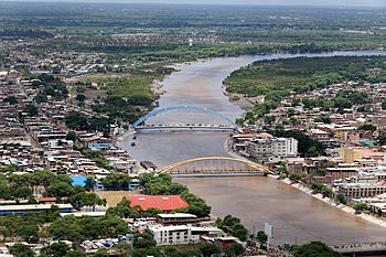
The Piura River in a flooded state flowing through Piura
|
|
|
Location of Piura River's mouth in Peru
|
|
| Region | Piura Region |
| Country | Peru |
| Physical characteristics | |
| River mouth | 5°46′20″S 80°52′07″W / 5.77222°S 80.86861°W |
| Length | 295 km (183 mi) |
| Basin features | |
| Basin size | 12,216 km2 (4,717 sq mi) |
The Piura River is a river located in northern Peru. It starts high up in the Andes mountains and flows west towards the Pacific Ocean. This river is well-known for sometimes having very large floods. The city of Piura is the biggest city found along the river's path.
Where the Piura River Flows
The Piura River begins in the eastern part of the Piura Region. Its source is near the continental divide in the Andes mountains. This part of the mountains is a bit lower than other areas in Peru.
The river first flows northwest for about 150 km (93 mi). It passes through a rich, fertile valley. This valley is a very important farming area for northern Peru.
When the river reaches Tambo Grande, it changes direction and turns west. The Piura River gets as close as 14 km (8.7 mi) to the Chira River. After this, it flows south into the dry Sechura Desert.
In the desert, the Piura River is a rare source of fresh water. It creates a green strip of land where crops can grow. The city of Piura is located in this fertile strip.
The Piura River has two places where it meets Sechura Bay. The largest amount of water flows out at a place called Laguna Ramon. In the past, the river's main exit was further north. However, big El Niño events in recent years have changed its flow. Now, much of the water goes to the south.
The Piura River is about 295 km (183 mi) long in total. The area of land that drains into the river, called its basin, is about 12,216 km2 (4,717 sq mi).
Why the Piura River Floods
The Piura River often experiences major floods. This happens because of its location near the changing southern edge of the Intertropical Convergence Zone (ITCZ).
Most years, the ITCZ stays north of coastal Peru. This causes the lower Piura River basin to be a very dry desert. But during El Niño events, the ITCZ moves further south. When this happens, it brings heavy, monsoon-like rains to the desert region.
During these rainy times, the Piura River, which is usually calm, can overflow its banks. This causes damaging floods in the city of Piura and other nearby towns.
The Piura River has had big floods in 1925, 1982-83, 1997-1998, and 2017.
See also
 In Spanish: Río Piura para niños
 | Georgia Louise Harris Brown |
 | Julian Abele |
 | Norma Merrick Sklarek |
 | William Sidney Pittman |


