Piute Pass facts for kids
Quick facts for kids Piute Pass |
|
|---|---|

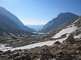
View from pass looking east
|
|
| Elevation | 11,417 ft (3,480 m) |
| Traversed by | Piute Pass Trail |
| Range | Sierra Nevada |
| Coordinates | 37°14′21″N 118°41′02″W / 37.2391011°N 118.6840025°W |
Piute Pass is a high mountain pass located in the beautiful Sierra Nevada mountains. It sits at an elevation of 11,417 feet (about 3,480 meters). This pass connects Inyo and Fresno Counties in California. It is found within the John Muir Wilderness, a protected natural area.
The pass is a popular route for hikers. It is crossed by the Piute Pass Trail. This trail links the famous John Muir Trail to the west. To the east, it connects to North Lake.
Contents
Exploring Piute Pass
What is a Mountain Pass?
A mountain pass is like a natural pathway through a mountain range. It is often the lowest or easiest point to cross over tall mountains. Piute Pass provides a way to travel between different parts of the Sierra Nevada.
A Look at Its History
For thousands of years, Native American people used Piute Pass. They traveled across the Sierra Nevada for trade. This shows how important the pass was for connecting communities.
In the 1920s, some groups wanted to build a highway over the pass. They thought it would be a beautiful scenic route. They even compared the area to the Swiss Alps. They hoped a highway would help the economies of both counties.
Protecting the Wilderness
However, the idea for a highway did not happen. By the 1930s, the plan was stopped. The Forest Service and the Sierra Club worked hard to protect the wilderness. They wanted to keep these natural areas safe from development.
Later, the Wilderness Act of 1964 was passed. This law helped create the John Muir Wilderness. This act made sure that places like Piute Pass would remain wild and untouched. Today, State Route 168 remains unbuilt between Huntington Lake and Lake Sabrina. This means the area around Piute Pass is still a beautiful wilderness.

