Pixie Mountain facts for kids
Quick facts for kids Pixie Mountain |
|
|---|---|

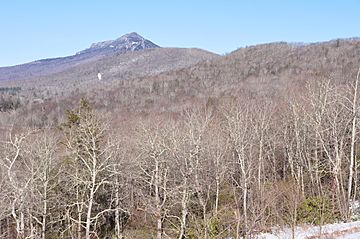
Grandfather Mountain (left) and Pixie Mountain (right)
|
|
| Highest point | |
| Elevation | 4,058 ft (1,237 m) |
| Geography | |
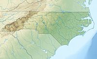
| Location | Avery County, North Carolina, U.S. |
| Parent range | Blue Ridge Mountains |
| Topo map | USGS Newland |
Pixie Mountain is a beautiful mountain located in the North Carolina High Country. This area is known for its tall mountains and stunning views. Pixie Mountain is found near the small community of Linville.
What is Pixie Mountain?
Pixie Mountain is a natural landmark in the western part of North Carolina. It is part of the famous Blue Ridge Mountains, which are known for their misty, blue appearance. The mountain stands next to the Linville River, a well-known river in the region.
Where is Pixie Mountain Located?
Pixie Mountain is in Avery County, North Carolina. The mountain is very close to the town of Linville. Most of the Linville community is located to the east and north of the mountain.
A road called the Linville Bypass (also known as NC Highway 181) goes around the western side of Pixie Mountain. This road helps people travel around the area easily.
How Tall is Pixie Mountain?
Pixie Mountain reaches a height of 4,058 feet (which is about 1,237 meters) above sea level. This makes it one of the many notable peaks in the North Carolina mountains. Its elevation offers great views of the surrounding landscape.
 | Toni Morrison |
 | Barack Obama |
 | Martin Luther King Jr. |
 | Ralph Bunche |


