Platter Kill facts for kids
Quick facts for kids Platter Kill |
|
|---|---|
|
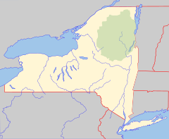
Location of mouth within New York
|
|
| Country | United States |
| State | New York |
| County | Schoharie |
| Physical characteristics | |
| Main source | 42°27′52″N 74°23′18″W / 42.4644444°N 74.3883333°W |
| River mouth | Schoharie Creek 932 ft (284 m) 42°24′19″N 74°27′03″W / 42.4053581°N 74.4507026°W |
| Length | 24.8 mi (39.9 km) |
| Basin features | |
| Basin size | 11 sq mi (28 km2) |
The Platter Kill is a small river, also known as a tributary, that flows into the Schoharie Creek. Think of it as a smaller stream that joins a bigger one.
The area of land that drains water into the Platter Kill is called its watershed. This watershed covers about 11 square miles (28 square kilometers). This is about 1.2 percent of the larger Schoharie Creek watershed.
How We Measure the River's Flow
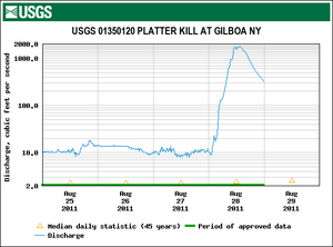
Scientists from the United States Geological Survey (USGS) keep track of how much water flows in the Platter Kill. They use a special tool called a stream gauge. This gauge has been working since 1975.
The stream gauge is located about 0.6 miles (1 kilometer) northwest of a town called Gilboa. It helps scientists understand the river's behavior.
River Flow During Big Storms
On August 28, 2011, the Platter Kill experienced a huge amount of water flow. This happened when Hurricane Irene passed through the area. The water flow reached 1,750 cubic feet per second. That's a lot of water moving very fast!
In contrast, on March 11, 2015, the river had its lowest recorded flow. It was only 0.31 cubic feet per second. This shows how much the river's flow can change.
 | James Van Der Zee |
 | Alma Thomas |
 | Ellis Wilson |
 | Margaret Taylor-Burroughs |


