Pleasant Plains, Arkansas facts for kids
Quick facts for kids
Pleasant Plains, Arkansas
|
|
|---|---|

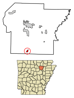
Location of Pleasant Plains in Independence County, Arkansas
|
|
| Country | United States |
| State | Arkansas |
| County | Independence |
| Area | |
| • Total | 1.01 sq mi (2.61 km2) |
| • Land | 1.01 sq mi (2.61 km2) |
| • Water | 0.00 sq mi (0.00 km2) |
| Elevation | 597 ft (182 m) |
| Population
(2020)
|
|
| • Total | 352 |
| • Density | 349.90/sq mi (135.11/km2) |
| Time zone | UTC-6 (Central (CST)) |
| • Summer (DST) | UTC-5 (CDT) |
| ZIP code |
72568
|
| Area code(s) | 501 |
| FIPS code | 05-56270 |
| GNIS feature ID | 2407136 |
Pleasant Plains is a small town located in Independence County, Arkansas, in the United States. In 2020, about 352 people lived there. This number was a little higher than the 349 people counted in 2010.
Contents
History of Pleasant Plains
Pleasant Plains is on an old path called the Southwest Trail. This trail was very important in the early 1800s. Most travelers who came into Arkansas used this path. The trail entered Pleasant Plains where U.S. Highway 167 is today.
From Pleasant Plains, the Southwest Trail continued towards Sunnydale using Arkansas Highway 157. It then went on to Center Hill and Floyd. By the 1830s, more than 80% of the people living in the Arkansas territory had arrived using this trail. It was also known as the Old Military Road and was the main route to Texas at that time.
Geography of the Town
Pleasant Plains is a small town that covers about 2.4 square kilometers (or 1.01 square miles). All of this area is land; there are no large bodies of water within the town limits.
Population and People
| Historical population | |||
|---|---|---|---|
| Census | Pop. | %± | |
| 1910 | 151 | — | |
| 1920 | 116 | −23.2% | |
| 1930 | 135 | 16.4% | |
| 1940 | 156 | 15.6% | |
| 1950 | 153 | −1.9% | |
| 1960 | 112 | −26.8% | |
| 1970 | 162 | 44.6% | |
| 1980 | 267 | 64.8% | |
| 1990 | 256 | −4.1% | |
| 2000 | 267 | 4.3% | |
| 2010 | 349 | 30.7% | |
| 2020 | 352 | 0.9% | |
| U.S. Decennial Census | |||
In 2000, there were 267 people living in Pleasant Plains. These people lived in 106 households, and 78 of those were families. The town had about 121 people per square kilometer (314 people per square mile).
Most of the people living in Pleasant Plains were White (94.76%). There were also people who identified as Native American (1.50%) or from other races (2.25%). Some people (1.50%) identified with two or more races. About 4.87% of the population was Hispanic or Latino.
About 34.9% of households had children under 18 living with them. More than half (56.6%) were married couples. The average household had 2.52 people, and the average family had 3.03 people.
The population was spread out by age. About 26.2% were under 18 years old. The median age in the town was 34 years. This means half the people were younger than 34 and half were older.
Education in Pleasant Plains
Since the 1985–86 school year, students in Pleasant Plains have attended schools in the Midland School District. This district was created when the former Pleasant Plains and Floral school districts joined together on July 1, 1985. The district includes Midland Elementary School and Midland High School. Both schools are located right in Pleasant Plains.
Transportation: Roads and Highways
You can get to Pleasant Plains using a few main roads:
See also
 In Spanish: Pleasant Plains (Arkansas) para niños

