Pocumtuck Mountain facts for kids
- Should not be confused with the Pocumtuck Range (Pocumtuck Ridge) of Deerfield and Greenfield, Massachusetts
Quick facts for kids Pocumtuck Mountain |
|
|---|---|

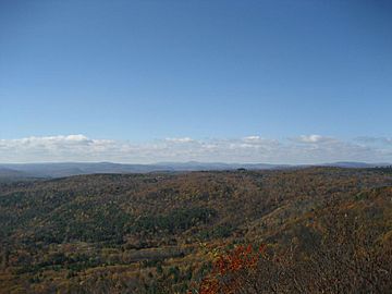
The western view from the summit ledge
|
|
| Highest point | |
| Elevation | 1,872 ft (571 m) |
| Geography | |
| Topo map | USGS Heath |
Pocumtuck Mountain is a cool peak located in Charlemont, Massachusetts. It sits west of a place called Catamount, which is now abandoned. From the top of Pocumtuck Mountain, you can see amazing views of western Franklin County and northern Berkshire County. People sometimes mix up Pocumtuck Mountain with the Pocumtuck Range, which is a different ridge nearby in Deerfield, Massachusetts.
A Look Back at Pocumtuck Mountain
Pocumtuck Mountain got its name from the Pocumtuc Indians. This happened on October 16, 1855. It was during one of Catamount's "Old Homes Days Festivals." These fun festivals were often held on the mountain because of its beautiful views. Even John Davis Long, who was the Governor of Massachusetts at the time, visited one of these special events.
Visiting Pocumtuck Mountain
Most of the land around Pocumtuck Mountain is privately owned. This means it belongs to individuals, not the public. There are some areas that are part of the Catamount State Forest. However, it's important to remember that you are not allowed to go onto private land without permission. Always respect private property when exploring nature.
 | Delilah Pierce |
 | Gordon Parks |
 | Augusta Savage |
 | Charles Ethan Porter |


