Pogledets Island facts for kids

Location of Varna Peninsula on Livingston Island in the South Shetland Islands
|
|
|
Location of Pogledets Island
|
|
| Geography | |
|---|---|
| Location | Antarctica |
| Coordinates | 62°27′39.7″S 60°09′30″W / 62.461028°S 60.15833°W |
| Archipelago | South Shetland Islands |
| Administration | |
| Administered under the Antarctic Treaty System | |
| Demographics | |
| Population | Uninhabited |
Pogledets Island is a small, ice-free island located in the cold waters of Antarctica. It is part of the South Shetland Islands, a group of islands near the Antarctic Peninsula. This crescent-shaped island faces southwest and is quite small. It stretches about 200 meters (656 feet) from north to south and 170 meters (558 feet) from east to west.
The island is named after Pogledets Peak. This peak is found in the Rila Mountain and also in the Stara Planina (Balkan Mountains) in Bulgaria.
Where is Pogledets Island Located?
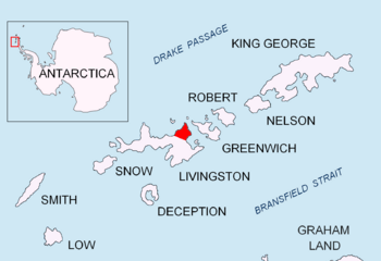
Pogledets Island is the most northern island in a group called the Dunbar Islands. It is located off the coast of Varna Peninsula, which is part of Livingston Island. Livingston Island is one of the larger islands in the South Shetland chain.
Nearby Islands and Landmarks
This small island is situated close to other interesting places. It is about 860 meters (2,822 feet) northeast of Zavala Island. Another island, Aspis Island, is located about 450 meters (1,476 feet) to the northwest. Further away, about 1.45 kilometers (0.9 miles) southwest, is Williams Point on Livingston Island.
Mapping and Discovery
The area around Pogledets Island has been explored and mapped over time. British explorers created maps of this region in 1968. Later, Bulgarian teams also mapped the area in 2009. This helps us understand the geography of this remote part of the world. In the early 1800s, sealers visited this area. They were looking for seals, which were common in these cold waters.


