
Aspis Island facts for kids

Location of Varna Peninsula on Livingston Island in the South Shetland Islands.
|
|

Aspis Island
Location in Antarctic Peninsula

Aspis Island
Location in Antarctica
Location of Aspis Island
|
|
| Geography | |
|---|---|
| Coordinates | 62°27′54.5″S 60°08′59.1″W / 62.465139°S 60.149750°W |
| Archipelago | Dunbar Islands |
| Highest elevation | 15 m (49 ft) |
| Administration | |
| Administered under the Antarctic Treaty System | |
| Demographics | |
| Population | Uninhabited |
Aspis Island is a small, flat island in Antarctica. It's part of the Dunbar Islands group. You can find it off the northwest coast of Varna Peninsula. This peninsula is on Livingston Island, which is in the South Shetland Islands. The island is only about 15 meters (49 feet) high. It doesn't have any ice on it.
The island got its name from the Aspis. This was a small, musical dragon often found in old stories.
Where is Aspis Island?
Aspis Island is located at coordinates 62°27′54.5″S, 60°08′59.1″W. It is about 520 meters (569 yards) west-northwest of Gargoyle Bastion. The island is also 670 meters (733 yards) north of Organpipe Point. It lies 800 meters (875 yards) northeast of Zavala Island. Aspis Island is about 1.59 kilometers (0.99 miles) south-southwest of Williams Point.
British maps from 1968 first showed this area. Later, Bulgarian maps in 2005 and 2009 confirmed its location.
Images for kids
-
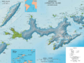
Topographic map of Livingston Island and Smith Island.
-
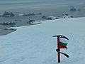
Aspis Island (showing next behind the second left point, the Organpipe) from Miziya Peak, with Zavala Island in the foreground and Zed Islands in the background.


