
Zed Islands facts for kids

Zed Islands (in the background) from Miziya Peak, Livingston Island
|
|

Location of Varna Peninsula on Livingston Island in the South Shetland Islands
|
|

Zed Islands
Location in Antarctica
|
|
| Geography | |
|---|---|
| Location | Antarctica |
| Coordinates | 62°26′00″S 60°09′15″W / 62.43333°S 60.15417°W |
| Archipelago | South Shetland Islands |
| Highest elevation | 290 m (950 ft) |
| Administration | |
| Administered under the Antarctic Treaty System | |
| Demographics | |
| Population | Uninhabited |
The Zed Islands are a small group of islands found near Livingston Island in Antarctica. They are part of the South Shetland Islands. The tallest island in the group reaches about 290 meters (951 feet) high.
These islands are located off the northeast tip of Livingston Island. They include four main islands: Esperanto Island, Phanagoria Island, Lesidren Island, and Koshava Island. There are also two nearby rocks called Dlagnya and Goritsa Rocks.
Contents
Where are the Zed Islands?
The Zed Islands are located at 62°26′00″S 60°09′15″W. This spot is in the icy continent of Antarctica. Many countries have mapped these islands over the years. These include Britain (in 1935 and 1968), Chile (1971), Argentina (1980), Spain (1991), and Bulgaria (2005 and 2009).
How were they named?
The name "Zed Islands" was likely given by a group of explorers. These explorers were part of the Discovery Investigations. They were on a ship called the Discovery II. They explored and mapped the islands in 1935.
Waterways around the islands
The Zed Islands are separated from a place called Williams Point by a channel of water. Williams Point is on Varna Peninsula, which is part of Livingston Island. The water channel is known as the Iglika Passage. It is about 0.93 miles (1.5 kilometers) wide.
Images for kids
-
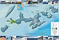
Topographic map of Livingston Island and nearby islands.

