Lesidren Island facts for kids

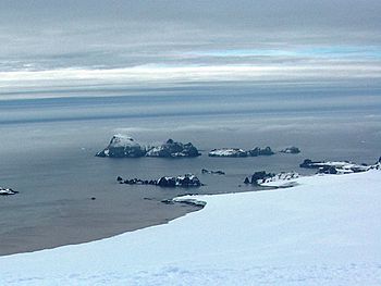
Zed Islands (in the background) from Miziya Peak; Lesidren Island is the second on the right.
|
|

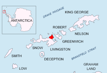
Location of Varna Peninsula in the South Shetland Islands
|
|
| Geography | |
|---|---|
| Location | Antarctica |
| Coordinates | 62°26′10″S 60°08′55″W / 62.43611°S 60.14861°W |
| Archipelago | Zed Islands |
| Area | 33 ha (82 acres) |
| Length | 0.8 km (0.5 mi) |
| Width | 0.6 km (0.37 mi) |
| Administration | |
| Administered under the Antarctic Treaty System | |
| Demographics | |
| Population | Uninhabited |
Lesidren Island is a small, ice-free island located in Antarctica. It is the second largest and southernmost island in the Zed Islands group. This group of islands is found off the north coast of Varna Peninsula on Livingston Island. Livingston Island is part of the South Shetland Islands.
The island is about 800 meters (0.5 miles) long and 600 meters (0.4 miles) wide. Its total surface area is about 33 hectares (81 acres). Lesidren Island is separated from its neighbors, Phanagoria Island and Koshava Island, by narrow channels. These channels are about 130 to 140 meters (142 to 153 yards) wide.
The name of the island comes from a settlement called Lesidren in northern Bulgaria.
Where is Lesidren Island?
Lesidren Island is located in the icy continent of Antarctica. You can find it at coordinates 62°26′10″S 60°08′55″W / 62.43611°S 60.14861°W. It is about 1.53 kilometers (0.95 miles) north of Williams Point on Livingston Island.
This area was first explored by sealers in the early 1800s. These were people who hunted seals for their fur and oil. Over the years, many countries have mapped this island. British maps were made in 1968, Chilean maps in 1971, and Argentine maps in 1980. Bulgaria also created maps in 2005 and 2009. This shows how different nations are interested in exploring and understanding Antarctica.


