
Koshava Island facts for kids

Zed Islands from Miziya Peak; Koshava Island is the rightmost one.
|
|

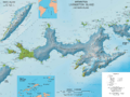
Location of Varna Peninsula in the South Shetland Islands
|
|

Koshava Island
Location in Antarctica

Koshava Island
Location in Antarctic Peninsula
|
|
| Geography | |
|---|---|
| Location | Antarctica |
| Coordinates | 62°25′59″S 60°08′11″W / 62.43306°S 60.13639°W |
| Archipelago | Zed Islands |
| Length | 0.34 km (0.211 mi) |
| Width | 0.22 km (0.137 mi) |
| Administration | |
| Administered under the Antarctic Treaty System | |
| Demographics | |
| Population | Uninhabited |
Koshava Island is a small island located in Antarctica. It's the island furthest to the east in a group called the Zed Islands. These islands are found near Livingston Island, which is part of the South Shetland Islands.
Even though it's in Antarctica, Koshava Island doesn't have ice on it. It's about 340 meters (1,115 feet) long and 220 meters (720 feet) wide. It's located near the entrance of a waterway called McFarlane Strait. It's also quite close to another island, Lesidren Island, and a place called Williams Point on Livingston Island.
Long ago, in the early 1800s, people who hunted seals used to visit this area. Koshava Island gets its name from a village called Koshava in Bulgaria.
Where is Koshava Island?
Koshava Island is located at 62°25′59″S 60°08′11″W / 62.43306°S 60.13639°W. Bulgarian scientists created a map of the island in 2009.
Images for kids
-
Topographic map of Livingston Island and Smith Island

