
Pollock, Missouri facts for kids
Quick facts for kids
Pollock, Missouri
|
|
|---|---|
|
Village
|
|

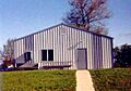
Former U.S. Post Office in Pollock
|
|

Location of Pollock, Missouri
|
|
| Country | United States |
| State | Missouri |
| County | Sullivan |
| Area | |
| • Total | 0.17 sq mi (0.43 km2) |
| • Land | 0.17 sq mi (0.43 km2) |
| • Water | 0.00 sq mi (0.00 km2) |
| Elevation | 974 ft (297 m) |
| Population
(2020)
|
|
| • Total | 46 |
| • Density | 277.11/sq mi (107.03/km2) |
| Time zone | UTC-6 (Central (CST)) |
| • Summer (DST) | UTC-5 (CDT) |
| ZIP code |
63560
|
| Area code(s) | 660 |
| FIPS code | 29-58898 |
| GNIS feature ID | 2398995 |
Pollock is a small village located in the northern part of Sullivan County, Missouri, United States. It is a quiet community with a population of 46 people, according to the 2020 census.
Contents
History of Pollock
Early Days and Growth
Pollock was first started in July 1873. Two people, H.F. Warner and William Lane, helped create the village. It began with 32 blocks of land. A few years later, in 1876, 14 more blocks were added to the south.
By 1877, Pollock had grown quite a bit. It had two general stores, a drug store, and a blacksmith shop. There was also a hotel, a school, and a small train station. The train station was for the Burlington & Southwestern Railroad. About 100 people lived in Pollock at that time. A United States Post Office opened in Pollock in 1879.
In January 1936, a big fire hit the business area of Pollock. Three buildings were completely destroyed. These included Rosenberry's Garage, Morlan General Store, and Anspach Cafe. Other stores, like O.L. Casto's and Miller's Store, were badly damaged.
Education in Pollock
Pollock had its own high school from 1923 to 1939. The classes were usually small because not many people lived in the town. On average, about ten students were in each graduating class. The smallest class had only three graduates in 1938. The largest class was in 1937, with thirteen students.
For a few years, from 1932 to 1937, the high school stopped offering junior and senior years. Students in those grades had to go to other towns to finish school. Many went to Milan, which was easy to reach by train. The Pollock high school closed for good after the 1939 graduation. All high school students from Pollock then went to the Milan school district. The elementary school stayed open a few years longer, into the mid-1950s. Today, all children in the Pollock area attend schools in the Milan C-2 school district.
Community Development
In the mid-1970s, Pollock built eight new apartments. These were in two buildings and were for older residents. A new metal community building was built in the late 1980s. An addition was put on this building in the late 1990s for the U.S. Post Office.
Around 1990, the community worked together to build a city park. Residents like William Casteel, Melvin Casto, and Dick Stewart led the effort. They raised money and got many volunteers to help. People from both near and far helped get park equipment and prepare the land.
Pollock faced a challenge on July 26, 2011. The United States Postal Service announced it would close the Pollock post office. This was part of a plan to reorganize post offices across the country. There was a similar attempt to close the post office in the late 1980s. That time, the closure was stopped with help from U.S. Senator Kit Bond and other Missouri politicians.
Where is Pollock?
Pollock is located about two miles south of the line between Sullivan and Putnam counties. The village is on Missouri Route M. This is about one mile east of Missouri Route 5. A part of the Burlington and Quincy Railroad runs along the west side of the town.
The United States Census Bureau states that Pollock covers a total area of 0.17 square miles (0.43 square kilometers). All of this area is land.
People of Pollock
| Historical population | |||
|---|---|---|---|
| Census | Pop. | %± | |
| 1880 | 104 | — | |
| 1980 | 102 | — | |
| 1990 | 66 | −35.3% | |
| 2000 | 131 | 98.5% | |
| 2010 | 89 | −32.1% | |
| 2020 | 46 | −48.3% | |
| U.S. Decennial Census | |||
The population of Pollock has changed over the years. In 1880, there were 104 people. By 2020, the population was 46.
2010 Census Information
In 2010, there were 89 people living in Pollock. These people lived in 39 households, with 25 of them being families. The average number of people in a household was 2.28. The average family size was 2.84 people.
The median age in the village was 43.5 years old. This means half the people were younger and half were older than 43.5. About 24.7% of the residents were under 18 years old. About 16.9% were 65 years or older. The population was almost evenly split between males (49.4%) and females (50.6%).
Images for kids
-
Pollock Community Center around 1994.

See also
 In Spanish: Pollock (Misuri) para niños
