Port-au-peck, New Jersey facts for kids
Quick facts for kids
Port-au-peck, New Jersey
|
|
|---|---|
| Country | |
| State | |
| County | Monmouth |
| Borough | Oceanport |
| Elevation | 20 ft (6 m) |
| Time zone | UTC−05:00 (Eastern (EST)) |
| • Summer (DST) | UTC−04:00 (EDT) |
| ZIP Code |
07757
|
| GNIS feature ID | 882544 |
Port-au-peck is a special neighborhood located within the town of Oceanport in Monmouth County, New Jersey. It is known as an unincorporated community, which means it's a recognized area without its own separate local government. The name Port-Au-Peck comes from the Lenape people, who were the first inhabitants of this land. In 1670, the land was transferred to English settlers. It's not fully clear how this land transfer happened or if the Lenape people understood they were giving up their rights to hunt and fish there.
Exploring Port-au-peck's Location
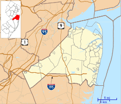
Port-au-peck covers about 3.9 square miles. This is roughly half of the entire area of Oceanport. It is located north-north-east of the New Jersey Transit Monmouth Park train line. This area forms a peninsula, which is a piece of land almost surrounded by water. It extends into the Shrewsbury River. People often describe its shape as looking like a mitten or even a fox.
Who Lives in Port-au-peck?
Even though Port-au-peck doesn't have its own specific population count (because it's part of Oceanport), it's generally seen as a neighborhood where families have a good income. Most homes here are residential, meaning people live in them rather than businesses operating there. It's considered a higher-income area compared to the Eatontown side of Oceanport.
Understanding the ZIP Code
Port-au-peck shares the same ZIP Code (07757) as the rest of Oceanport. This is because Oceanport only has one post office for all its residents. Because of this shared ZIP Code, Port-au-peck has sometimes been less recognized as a distinct place. Not many people in Oceanport use "Port-au-peck" as their mailing address.
 | Claudette Colvin |
 | Myrlie Evers-Williams |
 | Alberta Odell Jones |


