Port Alexander, Alaska facts for kids
Quick facts for kids
Port Alexander, Alaska
Shee Yat’aḵ.aan
|
|
|---|---|
| Country | United States |
| State | Alaska |
| Census Area | Prince of Wales-Hyder |
| Incorporated | July 9, 1974 |
| Area | |
| • Total | 15.01 sq mi (38.89 km2) |
| • Land | 3.50 sq mi (9.07 km2) |
| • Water | 11.51 sq mi (29.82 km2) |
| Elevation | 43 ft (13 m) |
| Population
(2020)
|
|
| • Total | 78 |
| • Density | 22.29/sq mi (8.60/km2) |
| Time zone | UTC-9 (Alaska (AKST)) |
| • Summer (DST) | UTC-8 (AKDT) |
| ZIP code |
99836
|
| Area code | 907 |
| FIPS code | 02-62510 |
| GNIS feature ID | 1424551 |
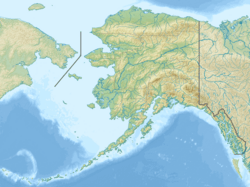
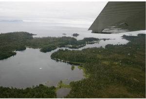
Port Alexander (in the Lingít language: Shee Yat’aḵ.aan) is a small city located at the southeastern tip of Baranof Island in Prince of Wales-Hyder Census Area, Alaska, United States. In 2010, the population was 52 people. By 2020, it had grown to 78 people.
Contents
History of Port Alexander
Port Alexander was once a very busy town. In the early 1900s, it had as many as 2,500 people. Before the 1920s, it was known as the main place for salmon fishing in the entire world!
The town officially became a city in 1936. Later, in 1963, it joined the Greater Sitka Borough. This happened after the state government passed a law that made towns join larger areas. In 1971, Port Alexander stopped being its own town when it joined with Sitka's city and borough governments. This created the larger City and Borough of Sitka.
However, the people living in Port Alexander wanted to run their own town again. They worked hard to separate from the new Sitka government. In 1974, they successfully became their own city once more. It is now known as a "second class city."
In the 2000s, the Port Alexander Historical Society opened a small museum. This museum celebrates the town's interesting history.
Geography and Location
Port Alexander is located at 56°14′24″N 134°39′26″W / 56.24000°N 134.65722°W.
It is the only city on a small piece of land at the southeastern corner of Baranof Island that is not part of the City and Borough of Sitka. The city covers less than one-quarter of one percent of Baranof Island's total land area.
According to the United States Census Bureau, the city has a total area of about 15.1 square miles (39.1 km²). Most of this area, about 11.3 square miles (29.3 km²), is water. Only about 3.8 square miles (9.8 km²) is land.
The city gets its supplies and mail weekly by a boat called the EYAK. There are also seasonal flights from Baranautica Air Service to the Port Alexander Seaplane Base.
Climate and Weather
Even though Port Alexander is far north, it has an oceanic climate. This means it has cool, wet winters with snow, and mild, drier summers.
| Climate data for Port Alexander, Alaska (1991–2020 normals, extremes 1949–2017) | |||||||||||||
|---|---|---|---|---|---|---|---|---|---|---|---|---|---|
| Month | Jan | Feb | Mar | Apr | May | Jun | Jul | Aug | Sep | Oct | Nov | Dec | Year |
| Record high °F (°C) | 52 (11) |
52 (11) |
54 (12) |
71 (22) |
77 (25) |
86 (30) |
84 (29) |
82 (28) |
74 (23) |
62 (17) |
55 (13) |
54 (12) |
86 (30) |
| Mean daily maximum °F (°C) | 39.7 (4.3) |
40.8 (4.9) |
43.1 (6.2) |
49.7 (9.8) |
56.7 (13.7) |
61.4 (16.3) |
64.3 (17.9) |
64.1 (17.8) |
58.4 (14.7) |
50.9 (10.5) |
44.2 (6.8) |
40.9 (4.9) |
51.2 (10.7) |
| Daily mean °F (°C) | 36.0 (2.2) |
36.7 (2.6) |
37.9 (3.3) |
43.2 (6.2) |
49.2 (9.6) |
54.1 (12.3) |
57.2 (14.0) |
57.2 (14.0) |
52.6 (11.4) |
46.3 (7.9) |
40.3 (4.6) |
37.2 (2.9) |
45.7 (7.6) |
| Mean daily minimum °F (°C) | 32.3 (0.2) |
32.5 (0.3) |
32.7 (0.4) |
36.8 (2.7) |
41.7 (5.4) |
46.7 (8.2) |
50.1 (10.1) |
50.2 (10.1) |
46.9 (8.3) |
41.6 (5.3) |
36.3 (2.4) |
33.4 (0.8) |
40.1 (4.5) |
| Record low °F (°C) | −1 (−18) |
4 (−16) |
7 (−14) |
18 (−8) |
28 (−2) |
33 (1) |
35 (2) |
37 (3) |
31 (−1) |
22 (−6) |
1 (−17) |
0 (−18) |
−1 (−18) |
| Average precipitation inches (mm) | 16.25 (413) |
11.72 (298) |
11.05 (281) |
8.64 (219) |
7.86 (200) |
6.65 (169) |
9.03 (229) |
13.94 (354) |
19.34 (491) |
19.85 (504) |
18.12 (460) |
19.58 (497) |
162.03 (4,116) |
| Average snowfall inches (cm) | 12.3 (31) |
12.0 (30) |
11.9 (30) |
1.2 (3.0) |
0.1 (0.25) |
0.0 (0.0) |
0.0 (0.0) |
0.0 (0.0) |
0.0 (0.0) |
0.3 (0.76) |
4.1 (10) |
14.1 (36) |
56.0 (142) |
| Average precipitation days (≥ 0.01 inch) | 23.7 | 19.4 | 21.5 | 19.2 | 16.6 | 15.5 | 16.6 | 18.5 | 23.3 | 25.3 | 24.1 | 24.4 | 248.1 |
| Average snowy days (≥ 0.1 in) | 5.7 | 4.8 | 4.9 | 1.2 | 0.1 | 0.0 | 0.0 | 0.0 | 0.0 | 0.2 | 2.5 | 4.9 | 24.3 |
| Source: NOAA (mean maxima/minima 1981–2010) | |||||||||||||
Population and People
| Historical population | |||
|---|---|---|---|
| Census | Pop. | %± | |
| 1930 | 107 | — | |
| 1940 | 87 | −18.7% | |
| 1950 | 22 | −74.7% | |
| 1960 | 18 | −18.2% | |
| 1970 | 36 | 100.0% | |
| 1980 | 86 | 138.9% | |
| 1990 | 119 | 38.4% | |
| 2000 | 81 | −31.9% | |
| 2010 | 52 | −35.8% | |
| 2020 | 78 | 50.0% | |
| U.S. Decennial Census | |||
Port Alexander first appeared in the U.S. Census in 1930 as a village. It officially became a city in 1936. After joining with Sitka in 1971, it later separated and became its own city again in 1974.
In the year 2000, there were 81 people living in Port Alexander. These people lived in 34 households, and 19 of those were families. Most of the people (about 84%) were White, and about 5% were Native American. About 11% of the population were from two or more racial backgrounds.
About 29% of the households had children under 18 living with them. Most households (58.8%) were married couples. The average household had about 2.38 people.
The median age of people in the city was 38 years old. About 30% of the population was under 18. About 33% were between 45 and 64 years old.
Education in Port Alexander
The local school in Port Alexander is called the Port Alexander School. It is managed by the Southeast Island School District. Students from the school even created a video in 2019, which you can watch here: Port Alexander School Video.
See also
 In Spanish: Port Alexander para niños
 | John T. Biggers |
 | Thomas Blackshear |
 | Mark Bradford |
 | Beverly Buchanan |


