Port Alsworth, Alaska facts for kids
Quick facts for kids
Port Alsworth, Alaska
|
|
|---|---|
Port Alsworth
|
|
| Country | United States |
| State | Alaska |
| Borough | Lake and Peninsula |
| Area | |
| • Total | 22.71 sq mi (58.81 km2) |
| • Land | 22.56 sq mi (58.43 km2) |
| • Water | 0.15 sq mi (0.39 km2) |
| Elevation | 253 ft (77 m) |
| Population
(2020)
|
|
| • Total | 186 |
| • Density | 8.25/sq mi (3.18/km2) |
| Time zone | UTC-9 (Alaska (AKST)) |
| • Summer (DST) | UTC-8 (AKDT) |
| ZIP code |
99653
|
| Area code(s) | 907 |
| FIPS code | 02-62620 |
| GNIS feature ID | 1408208 |
Port Alsworth is a small community in Alaska, United States. It is a census-designated place (CDP). This means it is a special area the government uses for counting people.
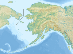
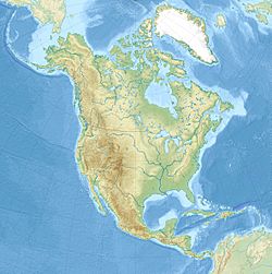
Port Alsworth is located in the Lake and Peninsula Borough. It is about 165 miles (266 km) southwest of Anchorage by air. In 2020, 186 people lived there. This makes it the largest community in its borough.
Contents
History of Port Alsworth
Port Alsworth was started in 1950. It was founded by Babe Alsworth (1909-2004) and Mary Alsworth (1923-1996). Babe was a missionary and a bush pilot. A bush pilot flies small planes to remote areas. Mary was the town's first postmaster.
The town is on private land. It is inside the Lake Clark National Park and Preserve. The national park's main office for the area is located here.
Community Life
A group called Samaritan's Purse runs a special lodge in Port Alsworth. It is for wounded United States military veterans. This program is called "Operation Heal Our Patriots" (OHOP).
There is also a summer camp here called "Tanalian Bible Camp". Young people from nearby villages, aged 8 to 19, can attend this camp.
The local school, Tanalian School, was renovated and made bigger. This happened from 2013 to 2014. The school's size tripled, and it got new furniture. The gym also became twice as big.
Where is Port Alsworth?
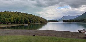
Port Alsworth is in the northern part of the Lake and Peninsula Borough. It is located at 60°12′30″N 154°18′24″W / 60.20833°N 154.30667°W. The town sits on the south shore of Lake Clark. It is right where the Tanalian River flows into the lake.
The community covers about 22.7 square miles (58.8 square kilometers). Most of this area is land, with a small amount of water.
Weather in Port Alsworth
Port Alsworth has a subarctic climate. This means it has very cold, long winters. The summers are short and cool.
| Climate data for Port Alsworth, Alaska, 1991–2020 normals, extremes 1960–present | |||||||||||||
|---|---|---|---|---|---|---|---|---|---|---|---|---|---|
| Month | Jan | Feb | Mar | Apr | May | Jun | Jul | Aug | Sep | Oct | Nov | Dec | Year |
| Record high °F (°C) | 58 (14) |
55 (13) |
59 (15) |
70 (21) |
85 (29) |
90 (32) |
91 (33) |
87 (31) |
77 (25) |
66 (19) |
56 (13) |
53 (12) |
91 (33) |
| Mean maximum °F (°C) | 45.3 (7.4) |
45.8 (7.7) |
47.8 (8.8) |
58.1 (14.5) |
71.6 (22.0) |
78.3 (25.7) |
80.4 (26.9) |
76.7 (24.8) |
66.4 (19.1) |
56.6 (13.7) |
46.8 (8.2) |
45.0 (7.2) |
82.3 (27.9) |
| Mean daily maximum °F (°C) | 24.0 (−4.4) |
30.2 (−1.0) |
34.9 (1.6) |
47.3 (8.5) |
58.6 (14.8) |
66.8 (19.3) |
69.1 (20.6) |
66.0 (18.9) |
57.1 (13.9) |
44.3 (6.8) |
32.2 (0.1) |
26.6 (−3.0) |
46.4 (8.0) |
| Daily mean °F (°C) | 16.8 (−8.4) |
22.5 (−5.3) |
25.1 (−3.8) |
38.5 (3.6) |
48.6 (9.2) |
56.7 (13.7) |
60.4 (15.8) |
57.7 (14.3) |
49.7 (9.8) |
38.1 (3.4) |
26.7 (−2.9) |
20.7 (−6.3) |
38.4 (3.6) |
| Mean daily minimum °F (°C) | 9.5 (−12.5) |
14.8 (−9.6) |
15.4 (−9.2) |
29.7 (−1.3) |
38.6 (3.7) |
46.6 (8.1) |
51.6 (10.9) |
49.3 (9.6) |
42.3 (5.7) |
31.9 (−0.1) |
21.2 (−6.0) |
14.7 (−9.6) |
30.5 (−0.8) |
| Mean minimum °F (°C) | −23.2 (−30.7) |
−19.7 (−28.7) |
−11.8 (−24.3) |
8.0 (−13.3) |
27.2 (−2.7) |
36.6 (2.6) |
43.4 (6.3) |
37.0 (2.8) |
27.8 (−2.3) |
14.1 (−9.9) |
−2.1 (−18.9) |
−13.3 (−25.2) |
−30.1 (−34.5) |
| Record low °F (°C) | −53 (−47) |
−55 (−48) |
−50 (−46) |
−18 (−28) |
13 (−11) |
20 (−7) |
25 (−4) |
22 (−6) |
13 (−11) |
−7 (−22) |
−24 (−31) |
−48 (−44) |
−55 (−48) |
| Average precipitation inches (mm) | 0.70 (18) |
0.85 (22) |
0.63 (16) |
0.50 (13) |
0.43 (11) |
0.73 (19) |
1.35 (34) |
1.70 (43) |
2.57 (65) |
1.32 (34) |
1.31 (33) |
0.98 (25) |
13.07 (332) |
| Average snowfall inches (cm) | 13.9 (35) |
13.1 (33) |
12.1 (31) |
7.2 (18) |
0.8 (2.0) |
0.0 (0.0) |
0.0 (0.0) |
0.0 (0.0) |
0.3 (0.76) |
4.9 (12) |
17.3 (44) |
18.3 (46) |
87.9 (223) |
| Average precipitation days (≥ 0.01 in) | 7.7 | 7.2 | 6.2 | 5.2 | 4.0 | 5.8 | 8.5 | 10.8 | 10.6 | 8.8 | 10.4 | 10.2 | 95.4 |
| Average snowy days (≥ 0.1 in) | 6.2 | 5.7 | 5.3 | 3.1 | 0.3 | 0.0 | 0.0 | 0.0 | 0.1 | 2.6 | 7.1 | 8.4 | 38.8 |
| Source: NOAA | |||||||||||||
Population Changes
| Historical population | |||
|---|---|---|---|
| Census | Pop. | %± | |
| 1940 | 18 | — | |
| 1960 | 34 | — | |
| 1990 | 55 | — | |
| 2000 | 104 | 89.1% | |
| 2010 | 159 | 52.9% | |
| 2020 | 186 | 17.0% | |
| U.S. Decennial Census | |||
Port Alsworth first appeared on the U.S. Census in 1940. Back then, it was called "Tanalian Point" and had 18 people. It was listed as Port Alsworth in 1960.
By 2000, 104 people lived in Port Alsworth. There were 34 households, and 24 of them were families. Many households (47.1%) had children under 18 living with them. Most households (67.6%) were married couples.
The people in Port Alsworth are of different ages. In 2000, about 41% were under 18. The average age was 26 years old.
Getting Around
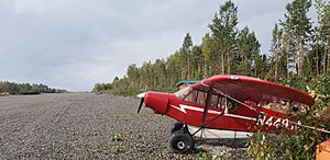
People usually travel to Port Alsworth by Air taxi. There are two airports in the area. One is the private Port Alsworth Airport. The other is the public Wilder/Natwick LLC Airport.
See also
 In Spanish: Port Alsworth (Alaska) para niños
 | Janet Taylor Pickett |
 | Synthia Saint James |
 | Howardena Pindell |
 | Faith Ringgold |


