Port Snettisham facts for kids
Quick facts for kids
Port Snettisham
|
|
|---|---|

Map
|
|
| Country | United States |
| State | Alaska |
| Time zone | UTC-9 (Alaska (AKST)) |
| • Summer (DST) | UTC-8 (AKDT) |
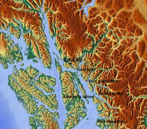
Port Snettisham is a narrow fjord (a long, narrow, deep inlet of the sea between high cliffs) located about 30 miles (48 km) southeast of Juneau, in the state of Alaska. It's a deep-water port, meaning large ships can easily dock there. It was developed to help transport valuable minerals found nearby.
Lieutenant Joseph Whidbey from the Royal Navy discovered this fjord on August 12, 1794. George Vancouver later named it after the town of Snettisham in England.
Contents
Geography of Port Snettisham
The entrance to Port Snettisham is on the northeast side of Stephens Passage. This is east of Admiralty Island. It's about 30 miles (50 km) southeast of Juneau. The port is also about 19 miles (30 km) from the Canada–US border.
The eastern shore has a very large bay. This bay is split into two smaller bays. One is called Holkham Bay, and the other is Port Snettisham itself. Port Snettisham is part of a system of waterways. These waterways are partially protected along the coasts of southeastern Alaska and Canada. It is a deep bay that was planned for transporting magnetite (a type of iron ore).
Branches of the Fjord
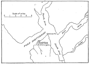
The fjord has three main branches.
- The North Arm has the Speel River at its end. This river flows quickly and goes into the Coast Range mountains for about 18 miles (29 km).
- The East Arm is a shorter inlet. The Whiting River flows into it, going through the mountains for about 35 miles (56 km). Small boats can travel about 4 miles (6.4 km) up this river.
- The South Arm has large flat areas at its end. These flats are bare at low tide for about 1 mile (1.6 km). Behind them is a low valley, about 5 miles (8 km) long, which connects to Holkham Bay.
From the shoreline, the land quickly rises to peaks. These peaks reach heights of 4,000 to 6,000 feet (1,200 to 1,800 meters). The Snettisham Peninsula is a piece of land with peaks around 2,500 feet (760 meters) high. It connects to the mainland by a low pass, less than 100 feet (30 meters) above sea level. The Snettisham post office is located on the north end of this peninsula. It is about 3 miles (4.8 km) inside the entrance to Port Snettisham.
People and History
Historically, the Taku people had several settlements at Port Snettisham. They still visit the area today, especially to fish for sockeye salmon.
Economy and Mining
Many valuable mineral deposits were found in the area around Port Snettisham. In 1954, iron ore deposits were found. They stretched for about 1,000 feet (300 meters) southwest of Sentinel Point. These deposits also extended into the southeastern shoreline of the port. It was suggested in 1954 to build a small dock there. This dock would be deep enough for large ocean-going ships.
Of all the minerals found, gold was the main one that was mined. The Alaska Snettisham Gold Mining Company was set up to mine gold. It was located on the south shore of Port Snettisham, about 3 miles (4.8 km) from the entrance.
Crystal Mine
The Crystal Mine was discovered in 1895 by B. Heins. It was a quartz ledge (a long, narrow raised part of land). By 1901, a 20-stamp mill was being used there. A stamp mill is a machine that crushes ore to get minerals out. The Alaska Snettisham Gold Mining Company bought this mine in 1903. However, mining operations stopped by 1905.
Iron Ore Property
The Port Snettisham Iron Ore Property is also located in Port Snettisham. It includes 49 connected properties, covering an area of 1,012 acres (410 hectares). This land is managed under an agreement between Arrowstar Resources Ltd. (which used to be Gulfside Minerals) and Pacific Rim Mineral.
 | Ernest Everett Just |
 | Mary Jackson |
 | Emmett Chappelle |
 | Marie Maynard Daly |


