Portland, Michigan facts for kids
Quick facts for kids
Portland, Michigan
|
|
|---|---|

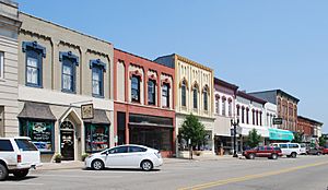
Kent Street, Portland, Michigan in 2011
|
|
| Nickname(s):
City of Two Rivers
|
|

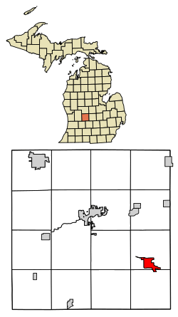
Location of Portland, Michigan
|
|
| Country | United States |
| State | Michigan |
| County | Ionia |
| Area | |
| • Total | 2.77 sq mi (7.18 km2) |
| • Land | 2.63 sq mi (6.81 km2) |
| • Water | 0.14 sq mi (0.37 km2) |
| Elevation | 715 ft (218 m) |
| Population
(2020)
|
|
| • Total | 3,796 |
| • Density | 1,443.90/sq mi (557.41/km2) |
| Time zone | UTC-5 (Eastern (EST)) |
| • Summer (DST) | UTC-4 (EDT) |
| ZIP code |
48875
|
| Area code(s) | 517 |
| FIPS code | 26-65860 |
| GNIS feature ID | 1626934 |
Portland is a city located in Ionia County, Michigan, in the United States. In 2020, about 3,796 people lived there. Portland is often called the "City of Two Rivers" because the Grand River and the Looking Glass River meet there. The city is home to Portland Public Schools and Portland Saint Patrick Catholic School.
Contents
History of Portland
The first land in what is now Portland was bought by Elisha Newman in 1833. Later that year, Philo Bogue built a trading post on the Grand River. Today, a park called Bogue Flats Recreation Area is named after him. Portland got its first post office in 1837. Native American tribes lived in this area for a long time. A famous Native American leader, John Okemos, lived here in the 1850s.
The first train came to Portland in 1869. Trains were an important way to travel and move goods. By 1881, six passenger trains arrived every day. The original wooden railroad bridge was replaced by a new one in 1881, which is still there today. The last train left Portland in 1984, and the tracks were removed. As Portland grew, it became a Village in 1869 and then a City in 1969. An opera house opened in 1880, and a library, built with money from Andrew Carnegie, opened in 1905.
Portland's Geography
Portland covers a total area of about 2.78 square miles (7.18 square kilometers). Most of this area, about 2.64 square miles (6.81 square kilometers), is land. The rest, about 0.14 square miles (0.37 square kilometers), is water, mainly from the two rivers that meet in the city.
Population Facts
| Historical population | |||
|---|---|---|---|
| Census | Pop. | %± | |
| 1860 | 440 | — | |
| 1870 | 1,060 | 140.9% | |
| 1880 | 1,670 | 57.5% | |
| 1890 | 1,678 | 0.5% | |
| 1900 | 1,874 | 11.7% | |
| 1910 | 1,832 | −2.2% | |
| 1920 | 1,899 | 3.7% | |
| 1930 | 1,902 | 0.2% | |
| 1940 | 2,247 | 18.1% | |
| 1950 | 2,807 | 24.9% | |
| 1960 | 3,330 | 18.6% | |
| 1970 | 3,817 | 14.6% | |
| 1980 | 3,963 | 3.8% | |
| 1990 | 3,889 | −1.9% | |
| 2000 | 3,789 | −2.6% | |
| 2010 | 3,883 | 2.5% | |
| 2020 | 3,796 | −2.2% | |
| U.S. Decennial Census | |||
What the 2010 Census Showed
In 2010, there were 3,883 people living in Portland. Most residents were White (96.7%). Smaller groups of African American, Native American, and Asian people also lived there. About 3.1% of the population was Hispanic or Latino.
There were 1,640 households in the city. Many homes (33.2%) had children under 18 living with them. About 46.1% of households were married couples. Some people lived alone, especially those aged 65 or older. The average household had about 2.37 people.
The average age of people in Portland was 35.6 years. About 25.4% of residents were under 18, and 13% were 65 or older. The population was almost evenly split between males (49%) and females (51%).
Famous People from Portland
- Martia L. Davis Berry (1844–1894), a political reformer who worked to improve society.
- Clarence Budington Kelland (1881–1964), a well-known writer.
See also
 In Spanish: Portland (Míchigan) para niños
 | Mary Eliza Mahoney |
 | Susie King Taylor |
 | Ida Gray |
 | Eliza Ann Grier |

