Potterville, Michigan facts for kids
Quick facts for kids
Potterville, Michigan
|
||
|---|---|---|
|
||

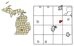
Location of Potterville, Michigan
|
||
| Country | United States | |
| State | Michigan | |
| County | Eaton | |
| Village | 1856 | |
| City | 1962 | |
| Government | ||
| • Type | Mayor-council | |
| Area | ||
| • Total | 1.88 sq mi (4.87 km2) | |
| • Land | 1.75 sq mi (4.52 km2) | |
| • Water | 0.14 sq mi (0.35 km2) | |
| Elevation | 902 ft (275 m) | |
| Population
(2020)
|
||
| • Total | 3,055 | |
| • Density | 1,749.71/sq mi (675.57/km2) | |
| Time zone | UTC-5 (Eastern (EST)) | |
| • Summer (DST) | UTC-4 (EDT) | |
| ZIP code |
48876
|
|
| Area code(s) | 517 | |
| FIPS code | 26-66100 | |
| GNIS feature ID | 1626939 | |
| Website | http://www.pottervillemi.org/ | |
Potterville is a city located in Eaton County, in the state of Michigan, United States. In 2010, about 2,617 people lived there.
Contents
History of Potterville
Potterville got its name from Linus Potter. He and his family settled in this area in November 1844. Linus was an important person in the community, becoming the supervisor of Benton Township in 1846.
Before coming to Michigan, Linus and his wife Diantha traveled a long way from New York. In 1830, they used the Erie Canal to get to Buffalo. Then, they took a steamboat across Lake Erie to Detroit. From Detroit, they walked about 30 miles to Plymouth, Michigan, and then continued to Saline. They carried their two young children, George and Louisa, on this journey.
Potterville officially became a village in 1881. Later, in 1962, it became a full city. When it became a city, it separated completely from Benton Township.
Some interesting events have happened in Potterville. On July 6, 1994, lightning struck near Fox Park. It hit the water and moved along the beach, causing injuries to 22 people.
Later that same year, on September 2, 1994, a rare earthquake happened near the city. The earthquake was a magnitude 3.5. People in most of Mid-Michigan could feel the ground shake.
In 2002, over Memorial Day weekend, a large train accident occurred. About 35 Canadian National train cars went off the tracks. Some cars were leaking propane, so everyone in the city had to leave their homes for safety. Investigators later found that a broken rail caused the accident.
Geography of Potterville
Potterville covers a total area of about 1.82 square miles (4.71 square kilometers). Most of this area, about 1.68 square miles (4.35 square kilometers), is land. The remaining 0.14 square miles (0.36 square kilometers) is water.
Population and People
| Historical population | |||
|---|---|---|---|
| Census | Pop. | %± | |
| 1880 | 471 | — | |
| 1890 | 505 | 7.2% | |
| 1900 | 495 | −2.0% | |
| 1910 | 430 | −13.1% | |
| 1920 | 330 | −23.3% | |
| 1930 | 492 | 49.1% | |
| 1940 | 547 | 11.2% | |
| 1950 | 624 | 14.1% | |
| 1960 | 1,028 | 64.7% | |
| 1970 | 1,280 | 24.5% | |
| 1980 | 1,502 | 17.3% | |
| 1990 | 1,523 | 1.4% | |
| 2000 | 2,168 | 42.4% | |
| 2010 | 2,617 | 20.7% | |
| 2020 | 3,055 | 16.7% | |
| U.S. Decennial Census | |||
Potterville in 2010
In 2010, there were 2,617 people living in Potterville. These people lived in 952 households, and 702 of these were families. The city had about 1,558 people per square mile (602 people per square kilometer).
Most of the people in Potterville were White (94.2%). There were also smaller groups of African American (1.3%), Native American (0.6%), and Asian (0.5%) residents. About 5.7% of the population identified as Hispanic or Latino.
Many households (45.4%) had children under 18 living with them. About 51.2% of households were married couples. The average household had 2.75 people, and the average family had 3.16 people.
The average age of people in the city was 32.4 years old. About 31.2% of residents were under 18, and 7.1% were 65 or older. The population was almost evenly split between males (48.6%) and females (51.4%).
Education in Potterville
Potterville has its own school district called Potterville Public School District. All the schools are on one campus along Main Street, near N. Hartel Road (M-100). The school mascot is the Vikings, and their colors are maroon and gold.
The campus includes an elementary school, a middle school, and a high school. It also has sports facilities, administration buildings, and a preschool.
Getting Around Potterville
Potterville is about 12.6 miles (20.2 kilometers) southwest of downtown Lansing. It is also 7 miles (11.2 kilometers) northeast of Charlotte. The city is located where Lansing Road meets Hartel Road/M-100.
You can easily get to major highways from Potterville. M-100 connects with I-69 just south of the city. M-100 also connects Potterville to I-96 north of Grand Ledge.
The city also has train service from the Canadian National Railway (CN) along its Flint Subdivision line.
Highways
 I-69
I-69- M-100
Famous People from Potterville
- Joe Davis is a well-known sportscaster for the Los Angeles Dodgers and FOX sports. He went to Potterville High School.
See also
 In Spanish: Potterville para niños
 | Sharif Bey |
 | Hale Woodruff |
 | Richmond Barthé |
 | Purvis Young |


