
Pottinger (District Electoral Area) facts for kids
Quick facts for kids PottingerDistrict Electoral Area |
|
|---|---|
 Map showing Pottinger wards within Belfast |
|
| Area | 6.17 km2 (2.38 sq mi) |
| Population | 31,272 (2008 Estimate) |
| • Density | 5,068/km2 (13,130/sq mi) |
| District | |
| County | |
| Country | Northern Ireland |
| Sovereign state | United Kingdom |
| EU Parliament | Northern Ireland |
| UK Parliament |
|
| NI Assembly |
|
Pottinger was a special area in Belfast, Northern Ireland. From 1985 to 2014, it was one of the nine "district electoral areas" (DEAs) in the city. Think of a DEA as a local neighborhood or section that elects people to help make decisions for the city.
Pottinger was located in the eastern part of Belfast. It elected six members to the Belfast City Council. These elected members are called councillors, and they work to represent the people living in their area.
The district included several smaller areas called wards: Ballymacarrett, Bloomfield, Orangefield, Ravenhill, The Mount, and Woodstock. Some of these wards, like Ravenhill and Woodstock, were part of the Belfast South area for bigger elections (like for the Northern Ireland Assembly and the UK Parliament). The other wards were part of the Belfast East area.
Pottinger was bordered by the River Lagan and Ormeau Road to the west. To the north, it met the Newtownards Road. On the east, it was bordered by Greenville Park and North Road. To the south, it touched the Borough of Castlereagh.
In 2001, most people in Pottinger were from a Protestant background. However, there was also a large number of people from a Catholic background. In some places, like the Short Strand, different communities lived very close to each other. Sometimes, peace lines were built to separate these areas.
Contents
History of Pottinger
Pottinger was created in 1985 for local elections. It mostly took the place of an older area called Electoral Area A. Five of its six wards came from Area A, and the Bloomfield ward joined from Area B.
Pottinger stopped being a district electoral area in 2014. Most of its wards then became part of a new area called Titanic. The Orangefield ward became part of another new area called Lisnasharragh.
Fun Places in Pottinger
There were several cool places to visit and enjoy in the Pottinger area:
- Ormeau Golf Club: A place where people could play golf.
- Ormeau Park: A large, beautiful park perfect for walks, sports, and relaxing.
- Ravenhill Stadium: This stadium is the home ground for the Ulster Rugby team, where exciting rugby matches are played.
Pottinger's Wards
Pottinger was made up of six smaller areas called wards. Each ward had its own unique community.
| Ward | NI Assembly Constituency | UK Parliament Constituency |
|---|---|---|
| Ballymacarrett | Belfast East | Belfast East |
| Bloomfield | Belfast East | Belfast East |
| Orangefield | Belfast East | Belfast East |
| Ravenhill | Belfast South | Belfast South |
| The Mount | Belfast East | Belfast East |
| Woodstock | Belfast South | Belfast South |
People Who Represented Pottinger
The people elected to represent Pottinger on the Belfast City Council were called councillors. They worked to improve the area for everyone. Different political parties had councillors elected from Pottinger over the years.
For example, in the 2011 election, the councillors elected were:
- Máire Hendron from the Alliance Party
- Niall Ó Donnghaile from Sinn Féin
- Adam Newton from the DUP
- May Campbell from the DUP
- Gavin Robinson from the DUP
- John Kyle from the PUP
Over time, the mix of parties representing Pottinger changed as people voted in different elections.
Images for kids
-
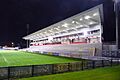
New stand at the Ravenhill Stadium, home of the Ulster Rugby team.
-
A gate in a peace line leading into the Short Strand area.


