Pouakai Range facts for kids
Quick facts for kids Pouakai Range |
|
|---|---|

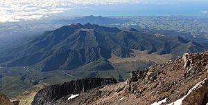
The Pouakai Range as seen from Mount Taranaki, with the Kaitake Range in the background.
|
|
| Highest point | |
| Peak | Pouakai |
| Elevation | 1,395 m (4,577 ft) |
| Geography | |
| Location | North Island, New Zealand |
The Pouakai Range is a group of mountains located on the North Island of New Zealand. You can find it to the northwest of the well-known Mount Taranaki. These mountains were formed by volcanoes long ago. They are actually what's left of a huge, ancient volcano that has worn away over many years.
Around the base of the Pouakai Range, there's a flat area made of old mud and rock flows. These flows, called lahars, were created by the volcano and are about 250,000 years old.
How the Pouakai Range Formed
The Pouakai Range was once a giant stratovolcano. This type of volcano is cone-shaped and built up by many layers of hardened lava, ash, and rock. Over hundreds of thousands of years, wind, rain, and ice have slowly worn down the volcano. This process, called erosion, has left behind the rugged mountains we see today.
The volcano that formed the Pouakai Range was active during the Pleistocene epoch. This was a time in Earth's history that lasted from about 2.6 million to 11,700 years ago. The range's highest point is a peak also called Pouakai, which reaches 1,395 meters (4,577 feet) high.
Other Volcanoes Nearby
The Pouakai Range is part of a volcanic area with other interesting formations. Here are some other volcanoes you can find in the region:
- Sugar Loaf Islands: These small islands are the oldest volcanic remains nearby, dating back about 1.7 million years.
- Kaitake Volcano: This volcano is older than Pouakai, forming around 500,000 years ago.
- Taranaki Volcano: This is the youngest and most famous volcano in the area, having formed about 127,000 years ago.
 | Jessica Watkins |
 | Robert Henry Lawrence Jr. |
 | Mae Jemison |
 | Sian Proctor |
 | Guion Bluford |

