Kaitake Range facts for kids
Quick facts for kids Kaitake Range |
|
|---|---|

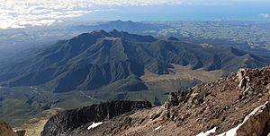
The Pouakai Range as seen from Mount Taranaki, with the Kaitake Range in the background.
|
|
| Highest point | |
| Peak | Patuha |
| Elevation | 675 m (2,215 ft) |
| Geography | |
| Location | North Island, New Zealand |
The Kaitake Range is a group of mountains in the North Island of New Zealand. It's the most north-western stratovolcano in the Taranaki area. A stratovolcano is a tall, cone-shaped volcano built up by many layers of hardened lava, ash, and rocks. Like the nearby Pouakai Range, Kaitake has been worn down by weather over a very long time. It's also covered in thick plants. It formed during the Pleistocene epoch, which was a long time ago, from about 2.6 million to 11,700 years ago.
The Kaitake Range is about 500,000 years old. It collapsed about 200,000 years later. This happened because the Pouakai Volcano also collapsed. Both Kaitake and Pouakai were damaged by eruptions from the Mount Taranaki volcano. The area was often changed after each cone collapse from Mount Taranaki.
Contents
Volcanoes in the Taranaki Region
The Taranaki region in New Zealand is home to several volcanoes. These volcanoes have shaped the land over millions of years. Here are some of the main ones:
Sugar Loaf Islands
The Sugar Loaf Islands are the oldest volcanoes in the area. They formed about 1.7 million years ago. These islands are now small, rocky outcrops off the coast.
Pouakai Volcano
The Pouakai Volcano is younger than the Sugar Loaf Islands. It was active between 500,000 and 250,000 years ago. Like Kaitake, it is now heavily eroded and covered in plants.
Mount Taranaki
Taranaki Volcano is the youngest and most active volcano in the region. It started forming about 127,000 years ago. It is still considered active today, though it hasn't erupted for a while.
How the Kaitake Volcano Formed
The Kaitake volcano started to become active during a period called "Hāwera time." This was a time when new volcanic activity began in the area. The Kaitake volcano was the first to appear on a new line of volcanic activity. It doesn't seem to be directly connected to the older Sugar Loaf Islands.
Early Volcanic Activity
Volcanic eruptions from Kaitake happened in three main stages. These stages were separated by times when the sea carved out cliffs along the coast. The rocks from the younger eruptions can be seen lying on top of old sea sediments. This shows how the land changed over time.
Shape of the Volcano
Today, the Kaitake volcano is very worn down by weather. So, its exact original shape is not fully known. However, the lower parts of the volcano are still well preserved. They suggest that Kaitake was a simple cone-shaped volcano. It was likely similar to Mount Taranaki in shape, rather than a complex volcano like those in Tongariro National Park.
After Kaitake's Activity
After the Kaitake volcano stopped erupting, new eruptions began at Pouakai. This volcano is about 6 miles (10 kilometers) south-east of Kaitake. The Pouakai volcano was active for a very long time. It went through periods of building up new land and periods of sea erosion. Eventually, its activity slowed down, and new eruptions started from the next volcanic center, which was Mount Taranaki.
 | Misty Copeland |
 | Raven Wilkinson |
 | Debra Austin |
 | Aesha Ash |

