
Powdersville, South Carolina facts for kids
Quick facts for kids
Powdersville
|
|
|---|---|

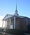
Top, left to right: Powdersville Branch Library, water tower, Saluda River, Powdersville Main, Highway 153, Bethesda Church, Powdersville Volunteer Fire Department
|
|

Powdersville, South Carolina
Location in South Carolina
|
|
| Country | United States |
| State | South Carolina |
| County | Anderson |
| Area | |
| • Total | 13.88 sq mi (35.94 km2) |
| • Land | 13.76 sq mi (35.63 km2) |
| • Water | 0.12 sq mi (0.30 km2) |
| Elevation | 968 ft (295 m) |
| Population
(2020)
|
|
| • Total | 10,025 |
| • Density | 728.67/sq mi (281.34/km2) |
| Time zone | UTC-5 (Eastern (EST)) |
| • Summer (DST) | UTC-4 (EDT) |
| FIPS code | 45-58165 |
| GNIS feature ID | 1250233 |
Powdersville is a community located in Anderson County, South Carolina. It is known as a census-designated place (CDP), which means it's an area identified by the U.S. Census Bureau for statistical purposes. In 2020, about 10,025 people lived in Powdersville.
Contents
History of Powdersville
The name Powdersville comes from the production of gunpowder in the area. One of the first shops here was called the Powdersville Area General Store. In 1859, a powder mill was built by John Bowen.
During the American Civil War, Powdersville was used to store gunpowder. However, Columbia was the main place where gunpowder was made in the state. Because of its connection to gunpowder, the name "Powders" became popular for the area.
In 1971, the Saluda Valley-Powdersville Water Company was started. It provided drinking water to about 1,200 homes. The name changed to Powdersville Water Company in 1992. Then, in 2001, it became the Powdersville Water District. The first high school in Powdersville, Powdersville High School, opened in 2011.
Geography and Location
Powdersville is in the northern part of Anderson County. Its northwest side borders Pickens County. The Saluda River forms its northeast border, which is also the line for Greenville County.
The southeast border of Powdersville is Interstate 85. This is a large highway with six lanes. You can get to Powdersville from exits 39 and 40. Greenville, the biggest city nearby, is about 8 miles (13 km) to the northeast.
The community covers a total area of about 13.9 square miles (36.3 square kilometers). Most of this area is land, with a small part being water.
Population and People
| Historical population | |||
|---|---|---|---|
| Census | Pop. | %± | |
| 2000 | 5,362 | — | |
| 2010 | 7,618 | 42.1% | |
| 2020 | 10,025 | 31.6% | |
| U.S. Decennial Census | |||

How Many People Live Here?
As of the 2020 United States census, there were 10,025 people living in Powdersville. There were 3,515 households and 2,570 families.
Who Lives in Powdersville?
Here's a look at the different groups of people living in Powdersville in 2020:
| Group | Number of People | Percentage |
|---|---|---|
| White (not Hispanic) | 7,515 | 74.96% |
| Black or African American (not Hispanic) | 926 | 9.24% |
| Native American | 14 | 0.14% |
| Asian | 508 | 5.07% |
| Pacific Islander | 6 | 0.06% |
| Other/Mixed | 406 | 4.05% |
| Hispanic or Latino | 650 | 6.48% |
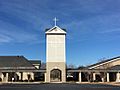
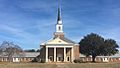
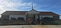
Religion in Powdersville
The largest religious group in Powdersville is Protestant. The oldest church in the area is Bethesda Church, which started in 1833.
-
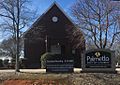
Palmetto Baptist Church
-
Bethesda United Methodist Church
-
Siloam Baptist Church
-
Lifespring Church of God
-
The Carpenters House
-
NewSpring Church Powdersville


Education in Powdersville

Public schools in Powdersville are managed by Anderson County School District One. The district runs several schools:
- Concrete Primary School
- Powdersville Elementary School
- Powdersville Middle School
- Powdersville High School
Powdersville also has a public library. It is a branch of the Anderson County Library System.
Transportation
State Highways
 SC 153
 SC 81
SC 81
Interstate Highway
See also
 In Spanish: Powderville para niños
