Prescott Island facts for kids
- This article is about the island in Nunavut, Canada. For the island in British Columbia, Canada, see Prescott Island (British Columbia).

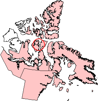
Prescott Island, Nunavut.
|
|
| Geography | |
|---|---|
| Location | Northern Canada |
| Coordinates | 73°03′N 096°50′W / 73.050°N 96.833°W |
| Archipelago | Canadian Arctic Archipelago |
| Area | 412 km2 (159 sq mi) |
| Administration | |
|
Canada
|
|
| Territory | Nunavut |
| Region | Qikiqtaaluk |
| Demographics | |
| Population | Uninhabited |
Prescott Island is a cool, uninhabited island way up north in Canada! It's part of the Canadian Arctic Archipelago, which is a huge group of islands in the Arctic. This island is located in Nunavut, a large territory in northern Canada.
You can find Prescott Island in a place called Peel Sound. It sits right between two other big islands: Prince of Wales Island and Somerset Island.
About Prescott Island
Prescott Island has an interesting oval shape. It covers an area of about 412 square kilometers. That's quite a bit of land, even though no one lives there!
This island isn't alone. It teams up with four smaller islands nearby. These are Binstead, Lock, Pandora, and Vivian. Together, these five islands form a kind of natural wall. They create a barrier at the entrance to Browne Bay. This bay is located on the eastern side of Prince of Wales Island.
See also
 In Spanish: Isla Prescott para niños
 | William M. Jackson |
 | Juan E. Gilbert |
 | Neil deGrasse Tyson |


