
Primrose, Alaska facts for kids
Quick facts for kids
Primrose, Alaska
|
|
|---|---|

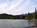
Primrose waterfront seen from Chugach National Forest campground
|
|

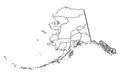
Location of Primrose, Alaska
|
|
| Country | United States |
| State | Alaska |
| Borough | Kenai Peninsula |
| Area | |
| • Total | 35.50 sq mi (91.96 km2) |
| • Land | 34.47 sq mi (89.27 km2) |
| • Water | 1.03 sq mi (2.68 km2) |
| Elevation | 3,212 ft (979 m) |
| Population
(2020)
|
|
| • Total | 96 |
| • Density | 2.79/sq mi (1.08/km2) |
| Time zone | UTC-9 (Alaska (AKST)) |
| • Summer (DST) | UTC-8 (AKDT) |
| Area code(s) | 907 |
| FIPS code | 02-64240 |
| GNIS feature ID | 2419191 |
Primrose is a small community in Alaska, United States. It is known as a census-designated place (CDP). This means it is a special area set up by the government for counting people. Primrose is located in the Kenai Peninsula Borough.
In 2020, about 96 people lived in Primrose. It is one of several small towns found north of Seward. These communities are all located along the scenic Seward Highway.
Contents
Exploring Primrose, Alaska
Primrose is found on the eastern side of the Kenai Peninsula. It sits right where the Snow River flows into Kenai Lake. This location is at 60°20′36″N 149°20′39″W / 60.34333°N 149.34417°W.
Nearby Communities
To the north of Primrose, you will find Crown Point. To the south, there is Bear Creek. The main road, Alaska Route 9 (also called the Seward Highway), goes right through Primrose. This highway leads south about 18 miles (29 km) to Seward. It also goes north the same distance to Alaska Route 1 at Tern Lake.
Land and Water Area
Primrose covers a total area of about 38.2 square miles (99.0 square kilometers). Most of this area is land, about 34.5 square miles (89.3 square kilometers). The rest is water, which makes up about 2.92% of the total area.
Population Changes in Primrose
Primrose was first counted as a census-designated place in the 1990 U.S. Census. Since then, its population has changed a few times.
| Historical population | |||
|---|---|---|---|
| Census | Pop. | %± | |
| 1990 | 63 | — | |
| 2000 | 93 | 47.6% | |
| 2010 | 78 | −16.1% | |
| 2020 | 96 | 23.1% | |
| U.S. Decennial Census | |||
Who Lives in Primrose?
In 2000, there were 93 people living in Primrose. These people lived in 33 households, and 29 of these were families. The community had about 2.5 people per square mile.
Many households (42.4%) had children under 18 living with them. Most households (75.8%) were married couples. The average household had 2.82 people, and the average family had 3.00 people.
The population in 2000 was spread out by age:
- 34.4% were under 18 years old.
- 1.1% were between 18 and 24.
- 24.7% were between 25 and 44.
- 28.0% were between 45 and 64.
- 11.8% were 65 years or older.
The average age of people in Primrose was 42 years. For every 100 females, there were about 93.8 males.
Images for kids
-
Primrose waterfront seen from Chugach National Forest campground
-
Location of Primrose, Alaska
See also

- In Spanish: Primrose (Alaska) para niños
