Protector Shoal facts for kids
Quick facts for kids Protector Shoal |
|
|---|---|

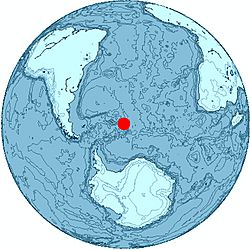
Location of Protector Shoal
|
|
| Summit depth | 55 metres (180 ft) |
| Height | 3,900 feet (1,200 m) |
| Location | |
| Location | 31 miles (50 km) NW of Zavodovski Island |
| Group | South Sandwich Islands |
| Coordinates | 56°01′S 28°25′W / 56.017°S 28.417°W |
| Country | United Kingdom |
| Geology | |
| Type | Seamount, Submarine volcano |
| Last eruption | 1962 |
| History | |
| Discovery date | 1962 |
| Discovered by | Royal Navy Ice Patrol Vessel H.M.S. Protector |
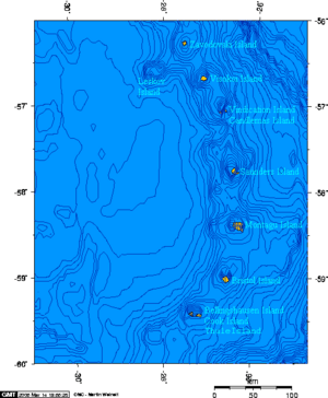
Protector Shoal is a special kind of volcano that is completely underwater. It's also known as a seamount, which is a mountain that rises from the ocean floor but doesn't reach the surface. Protector Shoal is located about 31 miles (50 km) northwest of Zavodovski Island in the South Sandwich Islands.
This underwater mountain rises from a deep part of the ocean, about 3,900 feet (1,200 m) below the surface. Its highest point is still about 55 metres (180 ft) below sea level. The last time this volcano erupted was in March 1962. It's unique because it's the only volcano in its area that has erupted a type of rock called rhyolite pumice.
Contents
What is a Seamount?
A seamount is basically a mountain under the sea. Most seamounts are old volcanoes that are no longer active. They are usually shaped like cones or peaks. Seamounts are important because they create special habitats for sea creatures. Many different kinds of fish, corals, and other marine life live around them.
Protector Shoal's Location
Protector Shoal is part of the South Sandwich Islands, which are a chain of islands in the southern Atlantic Ocean. These islands are known for their volcanic activity. Being underwater, Protector Shoal is not visible from the surface, but its presence affects the ocean currents and marine life around it.
The 1962 Eruption
The last known eruption of Protector Shoal happened in March 1962. When an underwater volcano erupts, it can release lava, ash, and gases into the ocean. This can heat the surrounding water and create new rock formations on the seafloor. Scientists study these eruptions to understand more about how our planet works.
Unique Rhyolite Pumice
Protector Shoal is special because it erupted rhyolite pumice.
- Rhyolite is a type of volcanic rock that is usually light in color. It forms from very thick, sticky lava.
- Pumice is a very light and porous volcanic rock. It forms when hot lava mixes with water or gas, creating a frothy, bubbly rock that can even float on water.
Finding rhyolite pumice from Protector Shoal is important because it tells scientists about the specific type of magma (molten rock) that was inside the volcano.
Discovery of Protector Shoal
Protector Shoal was discovered in 1962 by a ship from the Royal Navy called H.M.S. Protector. This ship was an Ice Patrol Vessel, meaning it was designed to travel through icy waters. The shoal was named after the ship that found it. Discovering underwater features like seamounts helps us map the ocean floor and learn more about the geology of our planet.
See also
 In Spanish: Banco Protector para niños
 | Toni Morrison |
 | Barack Obama |
 | Martin Luther King Jr. |
 | Ralph Bunche |


