Ptari-tepui facts for kids
Quick facts for kids Ptari-tepui |
|
|---|---|

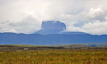
Ptari-tepui viewed from the east
|
|
| Highest point | |
| Elevation | 2,400 m (7,900 ft) |
| Geography | |
| Location | Bolívar, Venezuela |
Ptari-tepui is a special kind of mountain called a tepui. It's also known as Pu-tari or Cerro Budare. This amazing mountain is located in Bolívar state, Venezuela. It stands tall in the middle of the Sierra de Lema mountain range.
Ptari-tepui reaches about 2,400 meters (7,900 feet) above sea level. Its top is mostly flat and bare, covering an area of about 1.25 square kilometers (0.48 square miles). Even though the top is flat, you can find cool rock shapes on its eastern side. These shapes were made by erosion, which is when wind and water wear away rocks over time.
What is Ptari-tepui?
Ptari-tepui is part of a larger group of mountains called the Ptari Massif. A massif is a group of mountains that are connected. This massif also includes Carrao-tepui to the northeast and a long ridge called Sororopán-tepui to the southeast.
The entire Ptari Massif has a flat top area of about 2.5 square kilometers (0.97 square miles). The sides of these mountains cover an area of about 58 square kilometers (22 square miles). The Ptari Massif is completely inside Canaima National Park. This park helps protect these unique mountains and the plants and animals that live there.
Unique Shape of Ptari-tepui
Ptari-tepui is a great example of what a classic tepui looks like. It has a very flat top and sides that go almost straight down. This special shape is said to look like a budare. A budare is a type of griddle that people use to make cassava bread. This is why the mountain is sometimes called Cerro Budare or Cerro del Budare. The name Ptari comes from the Pemon language, which is spoken by the native people of the area.
See also
 In Spanish: Ptarí para niños
- Gran Sabana
- Distribution of Heliamphora
 | Roy Wilkins |
 | John Lewis |
 | Linda Carol Brown |


