
Gran Sabana facts for kids
The Gran Sabana is a huge, beautiful region in southeastern Venezuela. It's like a giant, open grassland that stretches into the Guiana Highlands and down towards the borders of Brazil and Guyana. This amazing area covers about 10,820 square kilometers (4,178 sq mi) and is part of Canaima National Park, which is the second largest national park in Venezuela!
Imagine a place with incredible landscapes: sparkling rivers, powerful waterfalls, deep valleys, thick jungles, and wide-open savannas. It's home to tons of different plants and animals, and it has unique flat-topped mountains called tepuis. The weather here is usually pleasant, around 20 °C (68 °F), but it can get cooler at night, especially on the higher mountains.
Contents
History of the Gran Sabana

Long ago, when Venezuela was a colony, people heard stories about a legendary place called El Dorado. They believed it was full of gold and precious gems. This made many adventurers and explorers come to this part of the world, hoping to find riches. Because of them, people started exploring this vast and wild land. Even today, some parts of the Gran Sabana are so remote that very few people have ever seen them!
Why Canaima Park Was Created
The southeastern part of Guayana, where the Gran Sabana is, has an incredible variety of plants, animals, minerals, and unique landforms. To protect this special place, the Venezuelan government decided to make it a national park.
So, on June 12, 1962, Canaima National Park was officially created. At first, it was about 1,000,000 hectares (3,900 sq mi). But in 1975, it was made much bigger to include more important natural areas, like the Gran Sabana itself. Now, Canaima National Park covers about 3,000,000 hectares (12,000 sq mi), making it one of the six largest national parks in the world!

In 1994, UNESCO recognized Canaima National Park as a World Heritage Site. This means it's considered very important for everyone in the world to protect. Thousands of tourists visit every year to enjoy its amazing natural beauty, including the tepuis, waterfalls, and diverse plants and animals. Scientists also come here because about 40% of all the plant species in Venezuela are found only in the Gran Sabana! Plus, 23% of its reptiles and amphibians are unique to this area.
The biggest town in the area is Santa Elena de Uairén. It has grown very quickly and now has over 30,000 people. It was founded in 1923 because people found diamonds nearby. Santa Elena is about 15 kilometers (9.3 mi) from the border with Brazil.
Geology of the Gran Sabana
The Gran Sabana sits on top of a very old rock formation called the Guyana Shield. The main rocks here are from the Roraima Group, which are about 1.4 to 1.8 billion years old! The tough Mataui Formation within this group forms the tall cliffs and flat tops of the tepuis. These rock layers are 600 to 900 meters (2,000 to 3,000 ft) thick and are made of strong quartzite.
The tops of the tepuis are usually 900 to 1,600 meters (3,000 to 5,200 ft) higher than the land around them. Because there's a lot of rain and the rocks have been weathering for a very long time, the quartzite and sandstone have formed unique shapes. You can find arches, towers, sinkholes, and even huge cave systems that stretch for many kilometers! Some parts of the tepui tops look like ancient ruins.
Geography of the Gran Sabana
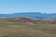
This region has gone through many changes over millions of years, with land rising and falling, and rocks being worn away. The large, isolated sandstone mountains that are left are called "tepuis" by the local people.
If you drive from El Dorado to Santa Elena de Uairén, the road climbs from 200 meters (660 ft) to 1,500 meters (4,900 ft) in just 30 kilometers (19 mi)! This steep part is called "La Escalera," which means "The Staircase." The rocky and sandy ground here supports savanna plants in higher areas, while thick jungles grow in lower spots and along rivers.

Rivers and Waterways
The Gran Sabana has many rivers and streams. The main rivers include the Yuruaní, Aponwao, Kukenán, and Caroní.

The Caroní River is very important. It's 925 kilometers (575 mi) long and flows with a lot of water. It provides most of Venezuela's electricity because many power plants use its water. The Caroní gets its water from several rivers that flow down from the tepuis and mountains of the Gran Sabana.
Most of the rivers and streams in this area have dark, tea-colored water. This is because the water has very few nutrients but is rich in natural acids from plants, which give it its unique brown color. The water is also quite acidic.
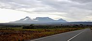
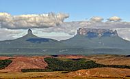
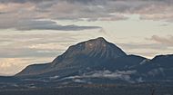
What Are Tepuis?
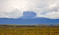
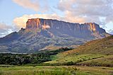
In the Gran Sabana, you'll see ancient, flat-topped mountains scattered around. These are the famous tepuis. They are like giant, natural tables sticking out of the ground. The highest tepui in the Gran Sabana is Mount Roraima, which is almost 2,800 meters (9,200 ft) above sea level!
Auyantepui
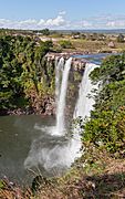
Even though Auyantepui isn't exactly inside the Gran Sabana's main area, many people consider it part of the region. It's the most famous tepui in all of Guiana because it's where the world's highest waterfall, Angel Falls, comes from! Angel Falls drops an amazing 979 meters (3,212 ft) straight down. The local people call it "Karepacupai-merú."

An American pilot named Jimmy Angel was the first non-indigenous person to make these falls known in 1937. He even tried to land his plane on top of Auyantepui, but he crashed (luckily, no one was hurt!). Auyantepui is the second largest tepui in Guiana, covering 700 square kilometers (270 sq mi). It's 2,535 meters (8,317 ft) high, but its surface is tilted, so one side is higher than the other.
You can climb Auyantepui from the southern side. Some parts require ropes, but it's not too difficult. To get there, you usually need to fly to the village of Kavak, as there are no roads.
Chimantá Massif
The Chimantá Massif is a group of 10 plateaus, and it's the largest tepui formation in Venezuela, covering 1,470 square kilometers (570 sq mi). It's not easy to reach, so tourists don't visit it often. A Venezuelan scientist named Charles Brewer Carías once discovered a huge cave entrance, 250 meters (820 ft) deep, while flying over this massif! Expeditions to this area have found new species, like a frog named Colostethus breweri after him.
Mount Roraima
.JPG)
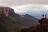
Mount Roraima is the highest tepui in Canaima National Park. It's also called Blue Mountain or Crystal Mountain. The local Pemon people believe it's a sacred place, home to powerful spirits. They respect and sometimes fear these spirits, and some even offer prayers when they visit the top.
Roraima is about 2,800 meters (9,200 ft) high and its flat top covers 200 square kilometers (77 sq mi). Its walls are completely vertical and can be up to 500 meters (1,600 ft) tall!

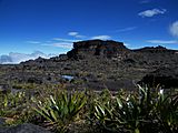
Despite the sheer walls, there's a path that allows tourists to climb to the top. Once there, you can explore amazing places like the Valley of the Crystals (full of quartz formations), the Jacuzzi area (with greenish-yellow water pools), and viewpoints like La Ventana. There's also the "Triple Point" where the borders of Brazil, Venezuela, and Guyana meet. You'll also see many interesting rock formations shaped by the wind, which look like animals or objects, like the "flying turtle" or the "elephant."
Kukenan (Matawi-tepui)
This tepui is often called Kukenan-tepui, but its real name is Matawi-tepui. It's 2,680 meters (8,790 ft) high. The first time people climbed it was in 1963. It's part of the eastern tepuis of the Gran Sabana, along with Yuruaní-tepui. Matawi-tepui is also home to Kukenan Falls, which is the tenth highest waterfall in the world, with a 629-meter (2,064 ft) drop!

Other Tepuis
Other well-known tepuis include the Ilú-Tramén-Karaurín chain, Wadaka-piapó, and Yuruaní. These, along with Kukenan and Roraima, form the chain of the 7 eastern tepuis. There are also Iglú-tepui, Ptarí-tepui, Acopán-tepui, and Sororopán-tepui, which you can climb.
Tramen Tepui, part of the Ilú–Tramen Massif, is 2,700 meters (8,900 ft) high and was first climbed in 1981.
There are about 150 tepuis in Canaima National Park, most of them between 2,000 and 2,700 meters (6,600 and 8,900 ft) tall.
-
Ptarí-tepui
-
Tepuis Ilú, Tramén and Karaurín
-
Tepuis Wadaka-piapó and Yuruaní
-
Moná-tepui
-
Tepui Chiricayen


Climate of the Gran Sabana
Temperature
Because the Gran Sabana is quite high up, about 1,000 meters (3,300 ft) on average, the weather is usually very pleasant. The average temperature is around 20 °C (68 °F).

However, it rains a lot throughout the year, and there are often clouds. This means the temperature can change a bit during the day. Minimum temperatures rarely drop below 8–10 °C (46–50 °F), unless you are on top of a very exposed tepui like Roraima at night. Maximum temperatures usually don't go above 32–35 °C (90–95 °F).

Precipitation
The rainy season in the Gran Sabana lasts for about 10 months, with a drier period from January to March. The area gets between 1,600 and 2,200 millimeters (63 and 87 in) of rain each year, which is twice as much as Venezuela's capital city! The amount of rain changes depending on where you are in the savanna.
Winds
When you first arrive in the Gran Sabana after climbing "La Escalera," you might notice strong, cool winds. These winds make the climate feel very comfortable. The weather here is mostly affected by how high up you are and the winds, since the region is close to the equator. Winds from the east and northeast bring a rainy and a dry season to the northern parts. In contrast, the south is affected by wet winds from the Amazon, which cause heavy rains when they hit the mountains.
Flora and Vegetation
The Gran Sabana is famous for its wide-open savannas, but it also has many other types of environments. These range from hot lowlands to cold high mountains, leading to a huge variety of plants. The plants here are special because they are adapted to grow in very acidic soils that come from broken-down sandstone.
You'll find savannas and "gallery forests" along the rivers and streams. These forests have many different trees, shrubs, and other plants. The shrubs are usually short, only 2–3 meters (6.6–9.8 ft) tall. Their leaves are often thick, probably because the soil is acidic and doesn't have many nutrients. The Gran Sabana also has many types of grasses, but they aren't good for feeding farm animals because the ground is so rocky and sandy.

Even on the harsh tops of the tepuis, there's a wide variety of plants, from tiny ones that are 20–30 centimeters (7.9–11.8 in) tall to small trees that are 4 meters (13 ft) high.
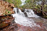
In the fast-flowing rivers and waterfalls, you can see unique green or tan plant "carpets" growing on the rocks. These are special plants from the Podostemaceae family. Higher up, at the base of the tepui cliffs, you'll find dense evergreen forests with many plants that grow on other plants (epiphytes). On the very tops of Auyantepui and the Chimantá Massif, there are several kinds of plants that don't grow anywhere else in the world! These include unique types of Brocchinia, Tepuia, and Heliamphora.
Botanists (plant scientists) love studying the plants here. You can find many carnivorous plants, like Heliamphora, Drosera, and Utricularia, which live in the thin layer of soil on top of the rocks. These plants eat insects to get the nutrients they need!
Fauna and Wildlife
Even though the Gran Sabana has a huge variety of animals, visitors don't often see them along the main roads. This is because most animals prefer to live in the forest "islands," along rivers, or in the thick jungles at the base of the tepuis.

Some of the animals living in the Gran Sabana are endangered, like the giant anteater, the giant armadillo, and the giant Amazon otter. You might also find monkeys like the Orinoco capuchin and howler monkeys. For birds, there's the colorful cock-of-the-rock and the powerful harpy eagle. Among reptiles, you can find boa constrictors and anacondas. Many types of amphibians, like the mining frog, live in the wet areas.
Other common animals include the armadillo, capybara (the world's largest rodent!), and sometimes even jaguars, pumas, and ocelots. You might also spot porcupines, kinkajous, and long-tailed weasels, which often live in trees. The bush dog is another interesting mammal, but it's rarely seen.
Because the tops of the tepuis have very few nutrients and harsh weather, there aren't many animals living up there.
Ethnic Groups

The Pemon people are the largest group of indigenous people in this region. They live all over Canaima National Park and are divided into three main groups: Arekunas, Taurepanes, and Kamarakotos. They are the original inhabitants of the Gran Sabana. Today, many Pemon people work in tourism, managing inns and guiding visitors on expeditions. We don't know the exact number of Pemon people, but a 2001 census showed that most of the 42,600 indigenous people in Bolívar state live in the Gran Sabana.
Languages Spoken
Almost all the indigenous people in this area speak Pemon, which is a language from the Carib family. Most of them also speak Spanish. In Santa Elena de Uairén, near the Brazilian border, it's also common to hear people speaking Portuguese.
Towns and Communities
Santa Elena de Uairén

As mentioned before, Santa Elena de Uairén is the main town and the capital of the Gran Sabana Municipality. It was named after the founder's first daughter, Elena, and the Uairén River. It has an airport, a military post, and has been a free port since 1999. Its economy relies on trade and mining, but tourism has grown a lot because it's close to the Gran Sabana's natural attractions and the Brazilian border. The town has grown quickly, and by 2016, it was estimated to have around 55,000 people. You can find hotels, shops for camping supplies, and businesses that buy and sell gold here.

Kavanayén
Kavanayén (also called Santa Teresita de Kavanayén) is an indigenous village mostly inhabited by the Pemon people. It's located within Canaima National Park. Capuchin missionaries founded the town in 1943. The buildings here are made from local stone using a technique developed by the missionaries. One important building is the Shrine of Santa Teresita de Kavanayén. The town also has a special residence for visiting presidents and a hydroelectric power generator.
El Paují
El Paují is a community about 75 kilometers (47 mi) west of Santa Elena de Uairén, close to the Brazilian border. The streets in El Paují are not paved, and while it has electricity, it often turns off before midnight. Most homes have their own generators. There's no cell phone service, but there's a communication center where you can access the internet. The community also has an airstrip, a rescue group, and a school. Tourists can find inns and restaurants. About 500 people live here, including artists, adventurers, miners, and beekeepers.
San Francisco de Yuruaní (Kumaracapai)

San Francisco de Yuruaní, also known as Kumarakapay in the native language, is an indigenous community located at "km 250" on the main road (Troncal 10). It's an important place for buying crafts and getting gas for tourists. You can find bracelets, necklaces, and many types of mineral stones from Bolívar state, like quartz, slate, and marble. The restaurants here offer local foods. The town has services like lodging, grocery stores, and health supplies. You can also arrange trips and excursions to other parts of Canaima National Park from here.
Other Communities
Other smaller communities include San Rafael de Kamoirán, known for its rapids, and Wönken, which has Capuchin missions. Paraitepuy de Roraima is usually where people start their hike to Mount Roraima. Iboriwo or Liwöriwö is a place where visitors can camp and visit the Aponwao Falls. Closer to the Canaima area, you'll find Kavak, Kamarata, Pupurken, Guayaraca, and Uruyén. These communities offer visitors the chance to go trekking or climb Auyantepui, with Pemon guides who know the area very well.
Tourism in the Gran Sabana
Getting Around the Gran Sabana

To reach the Gran Sabana, you need to drive on a paved road called Troncal 10, which goes through Ciudad Guayana and reaches the Brazilian border. Just before entering the Gran Sabana, you'll pass "La Escalera," a winding uphill road through a misty, rainy forest. After that, there's a paved road that runs through the Gran Sabana. Some other paths to interesting sites are not paved.
You can also fly to Santa Elena de Uairén. You can drive to Santa Elena from Caracas, or from Brazil via Pacaraima, using the BR174 highway that connects Manaus (about 1,000 km away) and Boa Vista (about 225 km away) to the Venezuelan border. There are buses from Ciudad Guayana to Santa Elena, but driving your own car is better so you can stop at interesting places. The drive from Caracas usually takes two days.
Some of the most beautiful places can only be reached with four-wheel-drive vehicles. These include Torón and Toroncito, Sakaika Rapids, Anaway Rapids, Käk Rapids, the village of Paraitepuy de Roraima, and several spots on the way to Ikabarú.

To get to Kavak, where the famous gorge is, you must travel by air. However, in late 2011, some unpaved roads, like the one to Torón River, were closed to vehicles because they were getting badly damaged. The most important waterfalls that are easy to reach from the main road without a four-wheel-drive vehicle are Kama Falls (or "Kama-Merú" in Pemon), Pacheco Falls (or "Arapan-Merú"), and Jasper Creek (or "Kako Paru").

Another thing to remember when traveling in the Gran Sabana is getting gasoline. There are only a few gas stations, and they aren't always open. The best place to find gas is in Santa Elena de Uairén, but that's over 200 kilometers (120 mi) from the Gran Sabana entrance. For foreign tourists, getting gas can be difficult because the government mainly provides it for Venezuelans. There can also be long lines during busy seasons. It's a good idea for tourists to carry extra fuel in properly marked red containers for safety.
Some parts of your trip can be done in "curiaras," which are wooden boats paddled by local people. These boats might even have engines to make the journey faster. For example, to reach Aponwao Falls, a famous waterfall with a 110-meter (360 ft) drop, you drive to Liwöriwö camp on dirt roads, then take a curiara guided by indigenous people for about 20 minutes to the falls.
Another popular, but more expensive, way to see the Gran Sabana is by helicopter or plane. You can take flights from many places, but Santa Elena de Uairén is the most common starting point. Some tours fly over Roraima and Kukenan tepuis, visit waterfalls, or fly over Auyantepui to see Angel Falls. They can also take you to camps in Canaima that aren't reachable by car.
Interesting Places to Visit

- Aponwao Falls (Chinak-meru)
- Kamá Falls (Kamá Meru)
- Kamá Falls (Kamá Mesalto)
- Falls Kawi (Kawí merú)
- Falls Kukenan
- Yuruaní Falls
- Karuay Falls
- Km "88" (a well-known spot on the road)
- La Laja
- El Paují
- El Abismo
- Santa Elena de Uairén
- Mission of Kavanayén
Photo gallery
-
A skyline from Mount Roraima
-
Falls Kamá
-
Jasper Creek
-
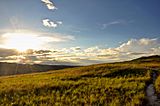
Typical landscape
-
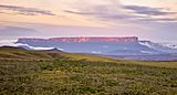
Last rays of the setting sun on the wall of the tepui Kukenan
-
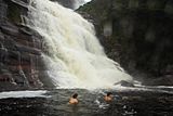
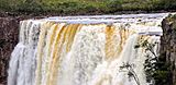
Falls Gran Sabana
-
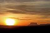
Tepui at sunset
-
Mount Roraima from Tëk River Camp
-
Blue Rock, the highest point of Mount Roraima
-
Upper Falls Aponwao


.JPG)


See also
 In Spanish: La Gran Sabana para niños
