
Tepui facts for kids
Quick facts for kids Tepui |
|
|---|---|

|
|

Ecoregion territory (in purple)
|
|
| Ecology | |
| Realm | Neotropical |
| Biome | tropical and subtropical moist broadleaf forests |
| Borders | Guianan Highlands moist forests, Guianan piedmont and lowland moist forests, and Guianan savanna |
| Geography | |
| Area | 50,675 km2 (19,566 sq mi) |
| Countries | Venezuela, Brazil, Guyana and Suriname |
| Conservation | |
| Conservation status | Relatively stable/intact |
| Protected | 37,658 km2 (74%) |
A tepui (pronounced "teh-POO-ee") is a special kind of flat-topped mountain. These amazing mountains are mostly found in northern South America. You can see them especially in Venezuela, western Guyana, and northern Brazil. The word "tepui" comes from the Pemon people, who live in the Gran Sabana region. In their language, "tepui" means "house of the gods."
Tepuis often stand alone, like giant natural islands. They are not usually connected in long mountain ranges. This isolation means they are home to many unique plants and animals. These species are found nowhere else on Earth. Some famous tepuis include Auyantepui, Autana, Neblina, and Mount Roraima. They are made of very old, hard sandstone and rise steeply from the surrounding jungle. Auyantepui is also the source of Angel Falls, which is the world's tallest waterfall.
Contents
How Tepuis Were Formed
Tepuis are like giant leftovers from a huge sandstone plateau. This plateau once covered a vast area between the Amazon Basin and the Orinoco River. It stretched from the Atlantic coast to the Rio Negro. This land was part of an ancient supercontinent called Gondwana.
Over hundreds of millions of years, this massive plateau slowly wore away. About 70 million years ago, the toughest parts that remained became the towering tepuis we see today. There are about 115 of these flat-topped mountains in the Gran Sabana area of southeastern Venezuela. This region borders Guyana and Brazil and has the most tepuis.
These impressive mountains can rise up to 1,000 meters (about 3,300 feet) above the surrounding land. Tepuis vary in height, from about 1,000 to 3,000 meters (3,300 to 9,800 feet) tall. The total flat area on top of all 115 tepuis is approximately 5,000 square kilometers (1,900 square miles).
Because they are so incredibly old, some tepuis have unique surface features and caves. These caves can be very deep, like the Abismo Guy Collet. This cave is 671 meters (2,201 feet) deep and is the deepest quartzite cave in the world. Some tepuis also have giant, almost perfectly round sinkholes. These sinkholes can be up to 300 meters (about 980 feet) wide and 300 meters deep. They form when the roofs of underground river tunnels collapse.
Life on the Tepuis: Plants and Animals
The flat tops of the tepuis are completely cut off from the forests below. This makes them like "ecological islands" high in the sky. The high altitude also gives them a different climate than the warm, humid jungle at their bases. The tops are cool and often rainy.
Because of this isolation, a unique world of plants and animals has developed over thousands of years. These special species are found only on the tepuis. They evolved separately from the rest of the world, protected by the steep rock walls. Some sinkholes on the tepuis even have their own unique species, like "islands within islands"! Scientists call the tepui region "Pantepui" because of its distinct living things.
Tepuis are often compared to the Galápagos Islands. This is because they have so many unique plants and animals found nowhere else. The soil on the tepui tops is very poor in nutrients. This has led to a fascinating variety of carnivorous plants. These include Drosera and many types of Heliamphora. You can also find many beautiful orchids and bromeliads here. The rocky ground means that rich soil layers don't form easily.
Scientists are still learning about how these unique species came to be. Some believe they evolved as the ancient plateau broke apart. Others think some species might have moved up from the lowlands and then changed over time. For example, a group of treefrogs called Tepuihyla seems to have evolved after the tepuis were formed.
These "islands above the rainforest" are a big challenge for researchers. They are home to many new species that have not yet been discovered or described. Some tepuis are covered by thick clouds almost all year. In the past, their surfaces could only be mapped using special radar from helicopters.
Explorations of the tepuis began in the 1800s with famous explorers like Alexander von Humboldt. Later, in the 1950s, scientists like Julian Steyermark and Bassett Maguire led many trips. Their goal was to record all the plants in the Venezuelan tepuis and nearby areas. This work resulted in a huge book series, Flora of the Venezuelan Guayana, published between 1995 and 2005. It described 2,447 plant species from the Pantepui region. An amazing 42% of these plants are found only on the tepuis, and 25% are found on just one mountain! More recently, between 2011 and 2014, five expeditions explored Brazilian tepuis.
Many tepuis are protected within Canaima National Park in Venezuela. This park is so important that UNESCO has named it a World Heritage Site.
Famous Tepuis to Explore
Here are a few of the most well-known tepuis:
- Auyantepui is the largest tepui. It covers an area of about 700 square kilometers (270 square miles). Angel Falls, the world's highest waterfall, plunges from a crack in its summit.
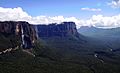
- Mount Roraima is also known as Roraima Tepui. A report by the famous explorer Robert Hermann Schomburgk inspired the author Arthur Conan Doyle. He wrote his novel The Lost World about a prehistoric world on a tepui. The borders of Venezuela, Brazil, and Guyana meet on its flat top.
- Matawi Tepui, also called Kukenán, is the source of the Kukenán River. The local Pemon people consider it the "place of the dead." It stands next to Mount Roraima in Venezuela.
- Autana Tepui rises 1,300 meters (about 4,300 feet) above the forest floor. A unique cave goes all the way through this mountain from one side to the other.
- Sarisariñama Tepui is famous for its almost perfectly circular sinkholes. These holes drop straight down from the mountain top. The largest is 300 meters (about 980 feet) wide and deep. They hide unique plants and animals at their bottoms.
- Ilú-Tramen Massif is the most northern mountain in a chain. This chain stretches along the Venezuela-Guyana border from Roraima in the south.
- Tafelberg in central Suriname is the easternmost tepui.
See also
- Canaima National Park
- Geography of South America
- Plateau
Images for kids
-
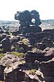
The plateau of Mount Roraima – peculiar rock formations caused by erosion.
-
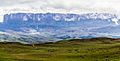
Mount Roraima
-
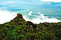
View of the Venezuelan Amazon from the top of a tepui
-
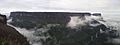
View of Kukenan tepui from top of Mt. Roraima
-
Devil's Canyon in the Canaima National Park
-
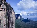
The steep rock wall of Mount Roraima


