
Santa Elena de Uairén facts for kids
Quick facts for kids
Santa Elena de Uairén
|
|
|---|---|
|
City
|
|
| The City of Santa Elena de Uairén | |
.jpg) |
|
| Nickname(s):
Santa Elena
|
|
.svg)
Santa Elena de Uairén
Location in Venezuela
|
|
| Country | |
| Region | Guayana |
| State | Bolívar |
| Municipality | Gran Sabana |
| Founded | November 13, 1923 |
| Elevation | 900 m (3,000 ft) |
| Population
(2006)
|
|
| • Total | 29,795 |
| Time zone | UTC−4 (VET) |
| Postal Code |
8052
|
| Area code | +58 288 |
| Climate | Am |
Santa Elena de Uairén is a city in Bolívar State, Venezuela. It is home to about 30,000 people (as of 2006). The city is very close to the borders of Brazil and Guyana.
A man named Lucas Fernández Peña started the city in 1923. Its name comes from his first daughter, Elena, and the Uairén River, which flows through the city.
Santa Elena is located in the middle of a beautiful area called La Gran Sabana. It's a popular spot for tourists, with many agencies offering trips to Canaima National Park. You can even take flights over the amazing Angel Falls or go hiking to the famous Monte Roraima.
This town is special because many indigenous people live here. There's even a community called Manakrü (say: mah-nah-CREE) where only indigenous people live. Schools in Manakrü teach in both Spanish and Pemon, which is their native language.
Because it's so close to Brazil, Santa Elena is a busy trading hub. People from Brazil buy Venezuelan oil and gas, and Venezuelans buy products from Brazil. Other Brazilian cities like Manaus, Santarém, Macapá, and Belém also trade with Santa Elena.
Santa Elena is known for being safer than many other cities in Venezuela.
Languages Spoken
- Spanish: This is the official language of Venezuela and is spoken by most people in Santa Elena.
- Pemon: Almost all the indigenous people in this area speak Pemon. It is a language from the Caribbean family, related to older languages like Tamanaco and Chaimas.
- Portuguese: Many people in Santa Elena de Uairén also speak Portuguese. This is because the city is so close to Brazil. In 1999, the city became a special "free zone." This means many Brazilians visit on weekends to buy food, electronics, and other items at lower prices.
Climate
| Climate data for Santa Elena De Uairen (1971–2000) | |||||||||||||
|---|---|---|---|---|---|---|---|---|---|---|---|---|---|
| Month | Jan | Feb | Mar | Apr | May | Jun | Jul | Aug | Sep | Oct | Nov | Dec | Year |
| Mean daily maximum °C (°F) | 27.5 (81.5) |
28.1 (82.6) |
28.4 (83.1) |
27.7 (81.9) |
26.9 (80.4) |
26.1 (79.0) |
26.0 (78.8) |
26.6 (79.9) |
27.5 (81.5) |
28.2 (82.8) |
27.8 (82.0) |
27.4 (81.3) |
27.4 (81.2) |
| Mean daily minimum °C (°F) | 16.6 (61.9) |
17.0 (62.6) |
17.4 (63.3) |
17.6 (63.7) |
17.8 (64.0) |
17.5 (63.5) |
16.8 (62.2) |
16.9 (62.4) |
16.7 (62.1) |
16.7 (62.1) |
16.8 (62.2) |
16.7 (62.1) |
17.0 (62.7) |
| Average precipitation mm (inches) | 76.3 (3.00) |
61.9 (2.44) |
94.7 (3.73) |
155.8 (6.13) |
237.3 (9.34) |
273.0 (10.75) |
250.8 (9.87) |
203.3 (8.00) |
130.9 (5.15) |
139.6 (5.50) |
111.8 (4.40) |
91.0 (3.58) |
1,826.4 (71.89) |
| Average precipitation days (≥ 0.1 mm) | 11.4 | 9.4 | 11.9 | 14.8 | 22.8 | 26.0 | 25.9 | 23.1 | 15.2 | 13.9 | 12.9 | 12.4 | 199.7 |
| Source: World Meteorological Organization | |||||||||||||
Neighboring Cities
Santa Elena de Uairén has special connections with other cities, known as "sister cities." These connections help them work together and share cultures.
 BRA Pacaraima, Roraima, Brazil
 VEN Ciudad Bolívar, Bolívar State, Venezuela
- VEN Upata, Bolívar State, Venezuela
- BRA Boa Vista, Roraima, Brazil
Images for kids
-
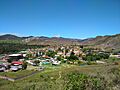
A view of Santa Elena de Uairén.
See also

In Spanish: Santa Elena de Uairén para niños
