Puebla de Yeltes facts for kids
Quick facts for kids
Puebla de Yeltes
|
||
|---|---|---|
|
||

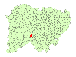
Location in Salamanca
|
||
| Country | Spain | |
| Autonomous community | Castile and León | |
| Province | Salamanca | |
| Comarca | Comarca de Ciudad Rodrigo | |
| Subcomarca | Campo del Yeltes | |
| Area | ||
| • Total | 37 km2 (14 sq mi) | |
| Elevation | 979 m (3,212 ft) | |
| Population
(2018)
|
||
| • Total | 149 | |
| • Density | 4.03/km2 (10.43/sq mi) | |
| Time zone | UTC+1 (CET) | |
| • Summer (DST) | UTC+2 (CEST) | |
| Postal code |
37606
|
|
Puebla de Yeltes is a small village and municipality located in western Spain. It is part of the Salamanca province, which is in the Castile and León region.
This charming village is about 65 kilometers (around 40 miles) away from Salamanca, the main city of the province. As of 2018, about 149 people live in Puebla de Yeltes.
Geography of Puebla de Yeltes
Puebla de Yeltes covers an area of 37 square kilometers (about 14 square miles). The village sits quite high up, at 979 meters (around 3,212 feet) above sea level. Its postal code is 37606.
Economy and Life in Puebla de Yeltes
The main way people make a living in Puebla de Yeltes is through agriculture. This means farming is very important to the village's economy.
See also
 In Spanish: Puebla de Yeltes para niños
Black History Month on Kiddle
Outstanding African-American Women
 | Laphonza Butler |
 | Daisy Bates |
 | Elizabeth Piper Ensley |

All content from Kiddle encyclopedia articles (including the article images and facts) can be freely used under Attribution-ShareAlike license, unless stated otherwise. Cite this article:
Puebla de Yeltes Facts for Kids. Kiddle Encyclopedia.

