Puerto Peñasco facts for kids
Quick facts for kids
Puerto Peñasco
Geʼe Ṣuidagĭ (O'odham language)
|
||
|---|---|---|
|
City
|
||

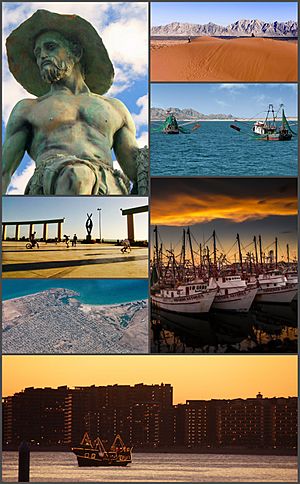
From top, left to right: Camaronero Monument, View of the Gran Desierto de Altar from Puerto Peñasco, Puerto Peñasco fishing vessels, Plaza Gobernadores, Aerial view of Puerto Penasco, Boats in the Puerto Peñasco fishing harbor, Skyline view at sunset
|
||
|
||
| Country | ||
| State | Sonora | |
| Municipality | Puerto Peñasco | |
| Founded | 1927 | |
| Municipal Status | 1952 | |
| Area | ||
| • Total | 9,774.45 km2 (3,773.94 sq mi) | |
| Elevation | 10 m (32 ft) | |
| Population
(2020)
|
||
| • Total | 62,689 | |
| Time zone | UTC-7 (Pacific (US Mountain)) | |
| • Summer (DST) | UTC-7 (No DST) | |
| Postal code (of seat) |
83550
|
|
| Area code(s) | 638 | |
Puerto Peñasco (O'odham: Geʼe Ṣuidagĭ) is a lively city in northwest Sonora, Mexico. It's about 100 kilometers (62 miles) from the Arizona border. In 2020, about 62,689 people lived there.
This city sits on the northern coast of the Sea of Cortez. It's part of the Altar Desert, which is a very dry and hot area. Many people call Puerto Peñasco "Rocky Point" in English. It's also known as "Arizona’s Beach" because it's the closest beach for cities like Phoenix and Tucson. The warm sea makes its climate much warmer than other coastal cities.
Since the late 1990s, Puerto Peñasco has grown into a popular tourist spot. Tourism and fishing are the main ways people make a living here. The city has many restaurants, hotels, and places for RVs. A new cruise ship terminal, called "Home Port del Mar de Cortés," is being built.
Contents
History of Puerto Peñasco
The city has two main names: Puerto Peñasco (meaning "rocky cliff port") in Spanish and Rocky Point in English. In 1826, a British sailor named Robert William Hale Hardy explored this area. He was looking for pearls and valuable metals. He named the spot Rocky Point. This name was used on maps until President Lázaro Cárdenas changed it to Puerto Punta Peñasco. Later, people shortened it to Puerto Peñasco.
Early Days and Fishing History
Before the 1920s, this area was a safe harbor for fishermen. They came from other Mexican towns to camp and fish. They mainly caught a fish called totoaba, which was used for medicine. Even in the 1800s, fishermen from Arizona visited. But no one lived there permanently because there was no fresh drinking water.
Growth and Development
In the 1930s, President Lázaro Cárdenas built a railroad. This railroad connected Baja California to the rest of Mexico and passed through Puerto Peñasco. The town started to grow. In 1932, a police station was added. The railroad helped new communities form, and the city's layout began in the 1940s. Shrimp fishing also became important to the local economy.
In 1952, Puerto Peñasco became its own municipality, separate from Caborca. It included nearby towns like Sonoyta. In 1989, another municipality, Plutarco Elías Calles, was created from part of Puerto Peñasco.
Becoming a Tourist Destination
Until the 1990s, only campers and fishermen visited the beautiful beaches. In 1993, the government and private investors decided to make Puerto Peñasco a major tourist center. They wanted to use its close location to the United States. They built condos and other facilities.
The government invested a lot of money to improve roads and build an airport. The area was made a "free zone," meaning visitors from other countries could enter without a special visa (though a passport is still needed). This made it easy for people from Arizona, California, and Nevada to visit.
Even with some economic challenges in the mid-1990s, development continued. Between 2002 and 2007, the economy grew quickly. Puerto Peñasco quickly became a popular place for tourists.
City Life and Attractions
The oldest part of Puerto Peñasco is built on volcanic rock near the sea. The city is part of a "border free zone," which means visitors from the U.S. can drive here easily. This makes it a top spot for tourists from Arizona, California, and Nevada.
Puerto Peñasco is sometimes called "Arizona’s beach." Many visitors come for the beautiful beaches and to fish.
Beaches and Natural Wonders
The city has many beaches, including Sandy Beach, Las Conchas, and El Mirador. Sandy Beach is known for its light brown sand. A special feature of the beaches are the tidal pools. The ocean tides can rise and fall a lot, up to 8 meters (26 feet). At low tide, many tidal pools appear in the rocky areas. These pools used to be full of crabs, starfish, and other sea creatures.
East of Las Conchas, there's an estuary called Morúa. Thousands of birds, including many that migrate, live here.
Condos and Shopping
Many beachfront condominiums have been built, such as Las Conchas and Sandy Beach Resorts. These developments include golf courses, malls, and marinas. You can find crafts like shell jewelry, iron pieces, and carved ironwood for sale.
Education and Research
The Universidad de Sonora has two research centers in Puerto Peñasco. The Scientific and Technological Research Center and the Center for Desert Studies are open to visitors. These centers started in 1963 to find ways to remove salt from seawater. Later, they researched how to farm blue shrimp. This project has helped Mexico develop shrimp farming techniques.
The CET-MAR Aquarium is a marine research center that is open to the public. It has displays of sea animals like turtles, octopus, and many kinds of fish.
Visitors and Residents
Puerto Peñasco is a popular place for spring break for students from Arizona and California. Many people from the United States and Canada live here, especially retirees. Most restaurants have English menus, and many businesses accept U.S. dollars. The town even has newspapers in English.
Geography and Climate
Puerto Peñasco is in the northwest of Sonora, Mexico, south of Arizona. It's about 60 miles (97 km) from the Arizona border. You can drive there in about four hours from Phoenix or Tucson. The city is mostly flat, with a hill called Ballena near the port.
Desert Environment
The city is located in the Sonoran Desert. This desert stretches from Arizona and California down to Mexico. Because it's a desert, Puerto Peñasco has very hot summers and warm winters. You can see remnants of ancient volcanoes on the beaches.
Weather Patterns
Puerto Peñasco has a desert climate with very little rain, averaging about 10 rainy days a year. The average high temperature for the year is 27.5°C (81.5°F). In summer, temperatures often reach 40°C (104°F). The average low temperature is 17.5°C (63.5°F), and it rarely freezes.
Sometimes, a tropical storm or hurricane can reach the northern Gulf of California. Hurricane Kathleen in 1976, Hurricane Nora in 1997, and Hurricane Rosa in 2018 were some of the last hurricanes to affect the area. The Gulf waters make summer temperatures a bit milder than inland desert areas, but the humidity can make it feel very hot.
| Climate data for Puerto Peñasco (1981–2010), extremes (1971–present) | |||||||||||||
|---|---|---|---|---|---|---|---|---|---|---|---|---|---|
| Month | Jan | Feb | Mar | Apr | May | Jun | Jul | Aug | Sep | Oct | Nov | Dec | Year |
| Record high °C (°F) | 30.0 (86.0) |
31.2 (88.2) |
37.0 (98.6) |
40.6 (105.1) |
39.0 (102.2) |
43.0 (109.4) |
41.0 (105.8) |
42.4 (108.3) |
42.5 (108.5) |
40.0 (104.0) |
33.2 (91.8) |
27.0 (80.6) |
43.0 (109.4) |
| Mean daily maximum °C (°F) | 19.1 (66.4) |
20.3 (68.5) |
23.2 (73.8) |
26.1 (79.0) |
29.3 (84.7) |
32.5 (90.5) |
34.9 (94.8) |
35.7 (96.3) |
35.0 (95.0) |
30.3 (86.5) |
24.5 (76.1) |
18.8 (65.8) |
27.5 (81.5) |
| Daily mean °C (°F) | 14.2 (57.6) |
15.4 (59.7) |
17.7 (63.9) |
20.5 (68.9) |
23.9 (75.0) |
27.3 (81.1) |
31.0 (87.8) |
31.6 (88.9) |
30.2 (86.4) |
24.8 (76.6) |
18.9 (66.0) |
14.3 (57.7) |
22.5 (72.5) |
| Mean daily minimum °C (°F) | 9.3 (48.7) |
10.5 (50.9) |
12.3 (54.1) |
14.9 (58.8) |
18.5 (65.3) |
22.2 (72.0) |
27.2 (81.0) |
27.6 (81.7) |
25.4 (77.7) |
19.2 (66.6) |
13.3 (55.9) |
9.8 (49.6) |
17.5 (63.5) |
| Record low °C (°F) | −8.0 (17.6) |
−2.0 (28.4) |
−2.0 (28.4) |
2.0 (35.6) |
8.0 (46.4) |
11.5 (52.7) |
11.8 (53.2) |
17.0 (62.6) |
14.0 (57.2) |
2.0 (35.6) |
2.0 (35.6) |
−6.0 (21.2) |
−8.0 (17.6) |
| Average precipitation mm (inches) | 5.9 (0.23) |
8.9 (0.35) |
6.3 (0.25) |
2.9 (0.11) |
0.1 (0.00) |
0.3 (0.01) |
3.8 (0.15) |
1.6 (0.06) |
8.3 (0.33) |
7.8 (0.31) |
5.1 (0.20) |
15.0 (0.59) |
66.0 (2.60) |
| Average precipitation days (≥ 0.1 mm) | 1.2 | 1.4 | 1.2 | 0.6 | 0.0 | 0.1 | 0.9 | 0.4 | 0.7 | 1.2 | 0.8 | 1.9 | 10.4 |
| Average relative humidity (%) | 61 | 67 | 62 | 61 | 60 | 62 | 70 | 65 | 63 | 58 | 57 | 73 | 63 |
| Source: Servicio Meteorológico Nacional | |||||||||||||
| Jan | Feb | Mar | Apr | May | Jun | Jul | Aug | Sep | Oct | Nov | Dec |
|---|---|---|---|---|---|---|---|---|---|---|---|
| 63 °F 17 °C |
61 °F 16 °C |
63 °F 17 °C |
66 °F 19 °C |
70 °F 21 °C |
73 °F 23 °C |
79 °F 26 °C |
82 °F 28 °C |
82 °F 28 °C |
79 °F 26 °C |
73 °F 23 °C |
66 °F 19 °C |
Population Growth
| Historical population | ||
|---|---|---|
| Year | Pop. | ±% |
| 1990 | 26,625 | — |
| 1995 | 27,169 | +2.0% |
| 2000 | 31,157 | +14.7% |
| 2005 | 44,875 | +44.0% |
| 2010 | 57,342 | +27.8% |
| 2015 | 62,177 | +8.4% |
| 2020 | 62,689 | +0.8% |
| sources: | ||
In 2020, Puerto Peñasco had 62,689 residents. This makes it the eighth largest city in the state of Sonora. The city's population has doubled since the year 2000. This big increase is mainly because of the growth in tourism.
See also
In Spanish: Puerto Peñasco para niños
 | Delilah Pierce |
 | Gordon Parks |
 | Augusta Savage |
 | Charles Ethan Porter |


