Pukalani, Hawaii facts for kids
Quick facts for kids
Pukalani, Hawaii
|
|
|---|---|

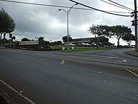
Intersection of Old Haleakala Highway and Pukalani Street in Pukalani
|
|

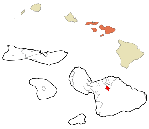
Location in Maui County and the state of Hawaii
|
|
| Country | United States |
| State | Hawaii |
| County | Maui |
| Area | |
| • Total | 3.77 sq mi (9.77 km2) |
| • Land | 3.77 sq mi (9.77 km2) |
| • Water | 0.00 sq mi (0.00 km2) |
| Elevation | 1,526 ft (465 m) |
| Population
(2020)
|
|
| • Total | 8,299 |
| • Density | 2,199.58/sq mi (849.18/km2) |
| Time zone | UTC-10 (Hawaii-Aleutian) |
| ZIP code |
96788
|
| Area code(s) | 808 |
| FIPS code | 15-65900 |
| GNIS feature ID | 0363512 |
Pukalani is a special kind of community in Maui County, Hawaiʻi, United States. It's called a census-designated place (CDP), which means it's an area that the government counts for population, but it's not officially a city or town. In 2020, about 8,299 people lived there.
Pukalani is located on the western slope of the Haleakalā volcano. This area, along with nearby places like Makawao and Kula, is known by locals as "Upcountry Maui." It's one of the four main population centers on Maui. The other three, Kahului, Lahaina, and Kīhei, are all right by the ocean.
Where is Pukalani Located?
Pukalani is found at these coordinates: 20°50′24″N 156°20′38″W / 20.84000°N 156.34389°W. It covers an area of about 11.1 square kilometers (or 3.77 square miles), and all of it is land.
The name Pukalani (pronounced Poo-cah-lah-nee) comes from the Hawaiian language. It means "window of heaven." This name fits perfectly because clouds often form both above and below the community on Haleakalā. This means Pukalani usually stays sunny. It also has cool and often breezy weather. From Pukalani, you can see the northern, western, and eastern parts of Maui. This is a special view that only a few places, like Haleakalā and Kula, offer.
Who Lives in Pukalani?
| Historical population | |||
|---|---|---|---|
| Census | Pop. | %± | |
| 2020 | 8,299 | — | |
| U.S. Decennial Census | |||
In 2000, there were 7,379 people living in Pukalani. They lived in 2,439 homes, and 1,904 of these were families. The community had about 1,671 people per square mile (or 645 people per square kilometer).
Many different groups of people live in Pukalani. About 34% of the residents were White, 28% were Asian, and about 7% were Pacific Islander. A large number, almost 29%, were from two or more racial backgrounds. About 9% of the population identified as Hispanic or Latino.
Families in Pukalani are often quite large. The average household had about 3 people, and the average family had about 3.3 people. Many homes (about 40%) had children under 18 living there. Most homes (about 59%) were married couples living together.
The median age in Pukalani was 37 years old. This means half the people were younger than 37, and half were older. About 28% of the population was under 18 years old.
Schools in Pukalani
Pukalani is home to several schools. It has a public high school called King Kekaulike High School. This school first opened its doors in 1995.
There are also two private schools in Pukalani:
- Kamehameha Schools Maui
- Carden Academy
See also
 In Spanish: Pukalani para niños
 | Victor J. Glover |
 | Yvonne Cagle |
 | Jeanette Epps |
 | Bernard A. Harris Jr. |

