Purisima Hills facts for kids
Quick facts for kids Purisima Hills |
|
|---|---|

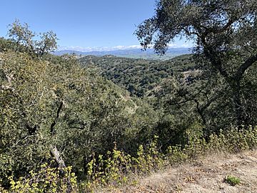
Looking North towards Los Alamos from Drum Canyon Road.
|
|
| Geography | |
| Country | United States |
| State | California |
| District | Santa Barbara |
| Range coordinates | 34°41′05″N 120°16′18″W / 34.68472°N 120.27167°W |
The Purisima Hills are a low mountain range in Santa Barbara County, California. These hills stretch from the northwest to the southeast. They act like a natural wall, separating the Santa Ynez Valley in the south from the Los Alamos Valley in the north.
Contents
What Are the Purisima Hills?
The Purisima Hills are part of a larger group of mountains called the Outer Southern California Coast Ranges. These ranges run along the coast of California. The Purisima Hills are not very tall, but they are an important part of the local landscape.
Where Are They Located?
The hills are found in Santa Barbara County, which is in the southern part of California. They help define the different valleys in the area. Imagine them as a natural divider between two neighborhoods.
Natural Resources and Wildlife
The Purisima Hills are known for a few important things. They are home to a valuable natural resource and a special type of tree.
Oil Production in the Hills
An important place called the Lompoc Oil Field is located in the Purisima Hills. This is where people find and collect oil from underground. Oil is a very useful resource that helps power cars and many other things. Because of this, the oil field is very important for the economy of the area.
Home to the Douglas-Fir Tree
The Purisima Hills are also special because they are the southernmost place where the coast Douglas-Fir tree naturally grows. This tree, known scientifically as Pseudotsuga menziesii var. menziesii, usually prefers cooler climates further north. Finding it here shows how unique the environment of the Purisima Hills is. It's like finding a polar bear living in Florida – it's unusual and interesting!
 | Madam C. J. Walker |
 | Janet Emerson Bashen |
 | Annie Turnbo Malone |
 | Maggie L. Walker |


