Puryear, Tennessee facts for kids
Quick facts for kids
Puryear, Tennessee
|
|
|---|---|

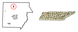
Location in Henry County, Tennessee
|
|
| Country | United States |
| State | Tennessee |
| County | Henry |
| Area | |
| • Total | 0.95 sq mi (2.45 km2) |
| • Land | 0.95 sq mi (2.45 km2) |
| • Water | 0.00 sq mi (0.00 km2) |
| Elevation | 607 ft (185 m) |
| Population
(2020)
|
|
| • Total | 706 |
| • Density | 745.51/sq mi (287.86/km2) |
| Time zone | UTC-6 (Central (CST)) |
| • Summer (DST) | UTC-5 (CDT) |
| ZIP code |
38251
|
| Area code(s) | 731 |
| FIPS code | 47-61160 |
| GNIS feature ID | 1298712 |
Puryear is a small city located in Henry County, Tennessee, in the United States. In 2020, about 706 people lived there. It's a quiet place with a history tied to the early days of railroads in the area.
Contents
History
Puryear was first called Littleton. It got this name from James T. Littleton. He was a farmer and a soldier who fought for the Southern states during the American Civil War. Mr. Littleton gave some of his land to a railroad company. This land was used to build the train tracks.
Later, a different railroad company took over. James Graves Littleton, James T. Littleton's son, suggested changing the town's name. This was because there were other towns named Littleton in Georgia and North Carolina. To avoid confusion, the town was renamed Puryear.
Geography
Puryear is in the northern part of Henry County. You can find it at these coordinates: 36°26′41″N 88°20′2″W / 36.44472°N 88.33389°W.
A main road, U.S. Route 641, goes through the eastern side of the city. If you go north on this road for about 4 miles, you'll reach Hazel, Kentucky. If you go south for about 10 miles, you'll get to Paris, which is the main town of Henry County.
Another important road, Tennessee State Route 140, runs through the middle of Puryear. Going east on this road for about 12 miles leads you to U.S. Route 79. This area is close to Paris Landing State Park and Kentucky Lake. If you go west for about 8 miles, you'll reach SR 69.
Puryear covers about 2.4 square kilometers (or 0.95 square miles) of land. There's no water area within the city limits.
An important natural feature nearby is the Tennessee Valley Divide. This is like an invisible line that separates where rainwater flows. Most of the water in Puryear flows north into the East Fork of the Clarks River. This river eventually reaches the Tennessee River. However, the westernmost part of Puryear sends its water west into Clear Creek. This creek flows into the North Fork of the Obion River, which then joins the mighty Mississippi River.
Population Facts
Puryear has grown over the years. Here's how the population has changed:
| Historical population | |||
|---|---|---|---|
| Census | Pop. | %± | |
| 1910 | 254 | — | |
| 1920 | 325 | 28.0% | |
| 1930 | 351 | 8.0% | |
| 1940 | 368 | 4.8% | |
| 1950 | 430 | 16.8% | |
| 1960 | 408 | −5.1% | |
| 1970 | 458 | 12.3% | |
| 1980 | 624 | 36.2% | |
| 1990 | 592 | −5.1% | |
| 2000 | 667 | 12.7% | |
| 2010 | 671 | 0.6% | |
| 2020 | 706 | 5.2% | |
| Sources: | |||
In 2000, there were 667 people living in Puryear. These people lived in 284 homes. About 191 of these homes were families. The average number of people in a household was about 2.27. For families, it was about 2.73 people.
The population was spread out by age. About 19.8% of the people were under 18 years old. About 21.7% were 65 years or older. The average age of people in Puryear was 41 years old.
See also
 In Spanish: Puryear (Tennessee) para niños
 | Bessie Coleman |
 | Spann Watson |
 | Jill E. Brown |
 | Sherman W. White |

