Purísima Concepción, Las Marías, Puerto Rico facts for kids
Quick facts for kids
Purísima Concepción
|
|
|---|---|
|
Barrio
|
|

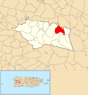
Location of Purísima Concepción within the municipality of Las Marías shown in red
|
|
| Commonwealth | |
| Municipality | |
| Area | |
| • Total | 2.13 sq mi (5.5 km2) |
| • Land | 2.10 sq mi (5.4 km2) |
| • Water | 0.03 sq mi (0.08 km2) |
| Elevation | 1,014 ft (309 m) |
| Population
(2010)
|
|
| • Total | 87 |
| • Density | 41.4/sq mi (16.0/km2) |
| Source: 2010 Census | |
| Time zone | UTC−4 (AST) |
Purísima Concepción is a small area, like a neighborhood, located in the town of Las Marías, Puerto Rico. In 2010, only 87 people lived there. It's a quiet place that's part of the beautiful island of Puerto Rico.
Contents
A Look Back: History of Purísima Concepción
How Puerto Rico Became Part of the U.S.
After the Spanish–American War ended in 1898, Spain gave Puerto Rico to the United States. This was part of a deal called the Treaty of Paris of 1898. Because of this, Puerto Rico became a special kind of territory of the United States. It's called an "unincorporated territory," which means it's part of the U.S. but doesn't have all the same rights as a state.
Early Population Counts
In 1899, the United States government did a count of all the people in Puerto Rico. This is called a census. The census found that 1,007 people lived in the Purísima Concepción area at that time.
| Historical population | |||
|---|---|---|---|
| Census | Pop. | %± | |
| 1900 | 1,007 | — | |
| 1980 | 137 | — | |
| 1990 | 185 | 35.0% | |
| 2000 | 144 | −22.2% | |
| 2010 | 87 | −39.6% | |
| U.S. Decennial Census 1899 (shown as 1900) 1910-1930 1930-1950 1980-2000 2010 |
|||
Exploring the Sectors of Purísima Concepción
What are Barrios and Sectors?
In Puerto Rico, a "barrio" is like a large neighborhood or a small district. These barrios are then divided into even smaller local areas. These smaller areas are called sectores (which means "sectors" in English).
Different Types of Sectors
The names for these sectors can be different. Some are just called "sector." Others might be called "urbanización" (a planned housing area), "reparto" (a land division), "barriada" (a settlement), or "residencial" (a housing project).
Sectors in Purísima Concepción
Here are the names of the sectors you can find in Purísima Concepción barrio:
- Camino Durán
- Camino El Porvenir
- Camino Las Vélez
- Carretera La Pura
- Hacienda Bauzá
- Sector Francisco Ramos
- Sector La Teresa
- Sector Los Millonarios
- Sector Luisa Mercado
- Sector Miguel Acevedo
See also
 In Spanish: Purísima Concepción (Las Marías) para niños
- List of communities in Puerto Rico
- List of barrios and sectors of Las Marías, Puerto Rico
 | William L. Dawson |
 | W. E. B. Du Bois |
 | Harry Belafonte |


