Quénonisca Lake facts for kids
Quick facts for kids Quénonisca Lake |
|
|---|---|

Watershed of Broadback River
|
|
| Location | Eeyou Istchee Baie-James (municipality) (RCM) |
| Coordinates | 50°35′57″N 76°32′03″W / 50.59917°N 76.53417°W |
| Type | Natural |
| Primary inflows | Broadback River, outlet of lake Opataouaga |
| Primary outflows | Marquette River West |
| Basin countries | Canada |
| Max. length | 7.6 kilometres (4.7 mi) |
| Max. width | 1.4 kilometres (0.87 mi) |
| Surface area | 51.68 kilometres (32.11 mi) |
| Surface elevation | 438 metres (1,437 ft) |
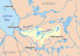
The Quénonisca Lake is a large freshwater lake located in the Eeyou Istchee Baie-James area of Quebec, Canada. It's a natural lake, meaning it wasn't made by people. The northern part of the lake is crossed by the Broadback River, which flows towards the west.
The main activity around the lake is forestry, which means cutting down trees. After forestry, tourism is important. People enjoy boating and other water activities on the Broadback River and Nipukatasi River, which flow into the lake.
You can reach the southern part of Quénonisca Lake by using a forest road. This road connects to another road that goes north.
The lake's surface usually freezes over from early November until mid-May. However, it's generally safe to walk or travel on the ice from mid-November to mid-April.
Exploring Quénonisca Lake's Geography
Quénonisca Lake is part of a group of lakes in the same area. These lakes are long and lie somewhat parallel to each other. Some nearby lakes include Salamandre Lake to the west and Rocher Lake to the east. The Nipukatasi River flows through Rocher Lake. Amisquioumisca Lake is also to the east.
Quénonisca Lake is about 56.9 kilometres (35.4 mi) long and 3.2 kilometres (2.0 mi) wide. It sits at an elevation of 258 metres (846 ft) above sea level and covers an area of 51.68 square kilometres (19.95 sq mi).
The lake gets most of its water from the outlet of Lake Opataouaga, which flows in from the south. This water enters a bay on the southeast shore. Another source of water is La Peupleraie lake, which flows into the northwest shore. The Broadback River also flows through the northern part of Quénonisca Lake.
Quénonisca Lake has 49 islands! One island is 5.1 kilometres (3.2 mi) long near the lake's mouth. Another island, about 5.0 kilometres (3.1 mi) long, is located near the southern part of Salamandre Lake.
Most areas around the lake are flat. However, there are some higher spots:
- To the northeast, near where the lake's water flows out, Mount Scott rises to 349 metres (1,145 ft). It's about 2.3 kilometres (1.4 mi) from the southeast shore.
- To the south, you'll find several mountains.
What's in a Name?
The name Quénonisca comes from the Cree language, specifically the Eastern Cree dialect. In Cree, this name means "the long lake," which perfectly describes its shape!
The name Lac Quénonisca was officially recognized on December 5, 1968. This happened when the Commission de toponymie du Québec (Quebec's place name commission) was first created.
 | Sharif Bey |
 | Hale Woodruff |
 | Richmond Barthé |
 | Purvis Young |


