Salamandre Lake facts for kids
Quick facts for kids Salamandre Lake |
|
|---|---|

Watershed of Broadback River
|
|
| Location | Eeyou Istchee Baie-James (municipality) (RCM) |
| Coordinates | 50°37′10″N 76°38′38″W / 50.61944°N 76.64389°W |
| Type | Natural |
| Primary inflows | Some forested creeks |
| Primary outflows | Salamandre River |
| Basin countries | Canada |
| Max. length | 14.9 kilometres (9.3 mi) |
| Max. width | 2.9 kilometres (1.8 mi) |
| Surface elevation | 265 metres (869 ft) |
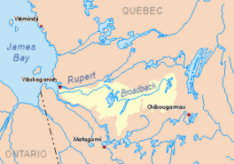
Salamandre Lake is a freshwater lake located in the Nord-du-Québec region of Quebec, Canada. It's part of the Eeyou Istchee Baie-James (municipality). The northern part of the lake is connected to the Broadback River, which flows through it towards the west.
The main activity in this area is forestry, which means harvesting trees for wood. After forestry, tourism is important. People enjoy boating and exploring the Broadback River and Nipukatasi River, which are connected to the lake.
You can reach the southern part of Salamandre Lake by using a forest road. This road connects to a main road that goes north. The lake usually freezes over from early November to mid-May. However, it's generally safe to walk or travel on the ice from mid-November to mid-April.
Contents
Exploring Salamandre Lake's Location
Salamandre Lake is one of several long lakes in its area. These lakes are mostly parallel to each other. To the east of Salamandre Lake, you'll find Quénonisca Lake, Rocher Lake (which the Nipukatasi River flows through), and Amisquioumisca Lake. On the west side, the biggest body of water is Evans Lake.
How Big is Salamandre Lake?
Salamandre Lake is about 14.9 kilometres (9.3 mi) long and 2.9 kilometres (1.8 mi) wide. It sits at an elevation of 265 metres (869 ft) above sea level. The lake gets most of its water from small streams that flow through the surrounding forests. The land around the lake is mostly flat.
Where Does the Water Go?
The water from Salamandre Lake flows out through the Salamandre River. This river is about 47.3 kilometres (29.4 mi) long. It flows west and eventually joins the Broadback River. The Salamandre River then continues for about 15.3 kilometres (9.5 mi) until it reaches Corbeau Bay, which is part of Evans Lake.
Distances to Key Places
The mouth of Salamandre Lake is located:
- About 12.9 kilometres (8.0 mi) south of where the Salamandre River meets the Broadback River.
- About 44.8 kilometres (27.8 mi) south-east of the mouth of Evans Lake.
- About 175.7 kilometres (109.2 mi) east of the mouth of the Broadback River where it flows into James Bay.
- About 125 kilometres (78 mi) north-east of the town of Matagami.
- About 178.4 kilometres (110.9 mi) west of the town of Chibougamau.
Understanding Salamandre Lake's Rocks
The area around Salamandre Lake has special rock formations. Geologists, who study rocks, call this the "Rocher-Salamandre intrusive suite." This group of rocks includes the Whitefish Intrusion and the Rock Intrusion. These rocks are found mainly between Salamandre Lake and Rocher Lake.
Scientists first described these rocks in 1974. They were later renamed the "Rocher-Salamander Intrusive Suite" in 1998. More recent studies in 2017 helped add more details about the different types of rocks found here.
The Name of Salamandre Lake
In the past, Salamandre Lake was sometimes called "Big Whitefish Lake" or in French, "Lac Poisson Blanc." This suggests that whitefish might have been common in the lake.
The official name, lac Salamandre, was formally recognized on December 5, 1968. This happened when the Commission de toponymie du Québec (Quebec's place-name commission) was created.
 | Precious Adams |
 | Lauren Anderson |
 | Janet Collins |


