
Queenstown Trail facts for kids
Quick facts for kids Queenstown Trail |
|
|---|---|

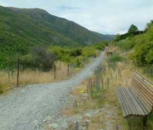
Start of the Queenstown end of the track
|
|
| Length | 110 km (68 mi) |
| Location | Queenstown, New Zealand |
| Trailheads | Queenstown / Arrowtown / Gibbston / Jack's Point |
| Use | Walking Running Cycling |
| Highest point | 425 m near Arrowtown |
| Lowest point | 300 m at Frankton Arm beach |
| Difficulty | Easy / Intermediate / Advanced (depending on track) |
| Season | Year round |
| Hazards | Cliffs / Vehicles |
The Queenstown Trail is an amazing network of paths in Otago, New Zealand. It's perfect for walking, running, or cycling! This trail connects several cool towns and areas. These include Queenstown, Arrowtown, Jack's Point, and Gibbston.
The trail is super long, stretching over 110 kilometers (about 68 miles). It doesn't just go in a straight line. Instead, it winds through beautiful landscapes, often following rivers and lakes. It links up many important spots. Sometimes, the trail even goes through private land like farms. So, it's important to stay on the marked path!
The Queenstown Trail was created with help from the Government, the Queenstown Lakes District Council, and the Queenstown Trails Trust. It's part of a bigger system called the New Zealand Cycle Trail.
Contents
Exploring the Queenstown Trail
The Queenstown Trail has many different paths you can explore. You can start and finish these routes from either end. Here are some of the most popular ones:
Frankton Track & Kelvin Peninsula Trail

This path connects Queenstown to the Kelvin Peninsula. It goes all around the Frankton Arm part of Lake Wakatipu. The trail starts near the Queenstown Gardens. Then, it follows Frankton Road close to the lake. It passes through Frankton and crosses the Kawarau Falls Bridge. The track finishes at the Kelvin Heights area on the Peninsula. You can keep going if you want to explore more!
Jack's Point Trail
This trail links the Kelvin Heights area (part of the Kelvin Peninsula) to Jack's Point. It begins near the Queenstown Golf Club. Along this path, you'll get wide-open views across Lake Wakatipu. You can see amazing mountains like Cecil Peak in the distance.
Countryside Trail
This route connects Queenstown and Arrowtown, passing through Frankton. It crosses the old Lower Shotover Bridge. This bridge goes over the Shotover River.
Lake Hayes Trail
.jpg)
This path goes all the way around Lake Hayes. You can start from different places, like the Lake Hayes Pavilion. There's also a picnic area at the north end of the lake. This trail connects to the nearby Lake Hayes Estate neighborhood. It used to be called the Lake Hayes Loop or Lake Hayes Circuit.
Twin Rivers Trail
This route connects Frankton with the Lake Hayes area. It also joins up with the Arrow River Bridges Trail. The path goes past both the Kawarau and Shotover Rivers. That's why it's called the "Twin Rivers" trail! It also passes the Lake Hayes Estate area. You can even take a side path to the Lake Hayes Loop. This trail was first called the Twin River Ride. It was changed to Twin Rivers Trail to show that many different people use it.
Arrow River Bridges Trail
.jpg)
This path connects Arrowtown to Gibbston. For most of its length, it follows the Arrow River. It can end at Chard Farm or link to the Gibbston River Trail. This trail has many cool bridges to cross. It also features The Barfoot Tunnel. This trail was first called the Arrow River Bridges Ride. It was changed to Arrow River Bridges Trail to show that many different people use it.
Gibbston River Trail
This route follows the Kawarau River through many vineyards in the Gibbston Valley. You can find parking lots at both ends of the track. There are also several loops, so you can choose a different or shorter route. This track was managed by the Department of Conservation. It was updated in 2014 to be bike-friendly and became part of the Queenstown Trail.
History of the Trail
The network of trails in this area was first called the Wakatipu Trails. Later, it was renamed The Queenstown Trail. Signs on the trail simply say Queenstown Trail.
The Wakatipu Trails Trust was started in 2002. This happened after a meeting to see if people wanted a network of fun trails. In 2004, a plan called the Wakatipu Trails strategy was made. This plan helped guide how the trails would be built. The main paths of the Queenstown Trail now connect with many smaller tracks. Many of these smaller tracks existed before the official trail opened.
Opening Day
The Queenstown Trail officially opened on October 18, 2012. However, many parts of the trail were already built and used by people before this date. The Prime Minister, John Key, and cyclist Sarah Ulmer officially opened it near Arrowtown. It took three years and over 100 workers to build the trail. It cost about $5.4 million (New Zealand Dollars).
Staying Safe on the Trail
Some parts of the trail have steep drop-offs, sometimes near rivers. Bad weather can cause small landslides. These might temporarily close parts of the track. Most of the trail is off-road, which means away from cars. But a few small sections cross roads or driveways.
It's also important to watch out for other people. Different users travel at different speeds. There are also quite a few blind corners. So, be careful to avoid bumping into others!
Cool Structures on the Trail
The Queenstown Trail features several interesting structures. There are three older bridges that were already there. Plus, six new structures were built just for the trail! These new structures include two wooden bridges, two suspension bridges, an underpass, and a tunnel. The bridges and tunnel built for the Queenstown Trail were named after families who gave money to help build them.
Pre-existing Structures
- Lower Shotover Bridge: This is a historic bridge that has been restored. It used to be for cars but is now used by cyclists and people walking.
- Kawarau Falls Bridge: This old bridge used to have space for walkers and a one-way section for cars. In 2018, a new bridge for cars was built nearby. Now, the Kawarau Falls Bridge is only for people walking or cycling.

- Kawarau Gorge Suspension Bridge: This is the famous bridge used by the AJ Hackett Bungy Company for bungee jumping!
Structures Built for the Trail
These structures were built so trail users could cross rivers or roads safely. They were funded by people who supported the project:
- The Edgar Bridge: This is an 80-meter (about 262 feet) suspension bridge over the Arrow Gorge. It's named after Sir Eion and Lady Edgar.
- The Barfoot Tunnel: This tunnel goes under State Highway 6. It was made possible by a donation from Garth and Judy Barfoot.
- The Knights Family Bridge: This is an underpass that goes beneath State Highway 6. It's named after the family who donated money for it.
- The Southern Discoveries Bridge: This is a second suspension bridge that crosses the Arrow River. It's near where the opening ceremony for the trail was held.
- The Swain Bridge: You can find the Swain Bridge on the Arrowtown Millennium Trail. It's named after Ken Swain, who was a trustee for the Queenstown Trails Trust.
- Billie’s Bridge: This is a small bridge that crosses Hayes Creek. Hayes Creek flows out of Lake Hayes into the Kawarau River. This bridge is named after a member of the Sargood family.
