Quimby Island facts for kids

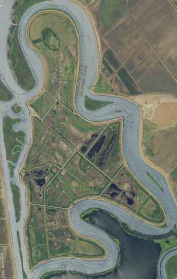
USGS aerial imagery of the island.
|
|
| Geography | |
|---|---|
| Location | Northern California |
| Coordinates | 38°01′31″N 121°34′17″W / 38.0251993°N 121.5713413°W |
| Adjacent bodies of water | Sacramento–San Joaquin River Delta |
| Area | 789 acres (319 ha) |
| Length | 2.25 mi (3.62 km) |
| Highest elevation | -10 ft (-3.05 m) |
| Administration | |
|
United States
|
|
| State | |
| County | Contra Costa |
Quimby Island is a small island located in the Sacramento–San Joaquin River Delta in Northern California. It is part of Contra Costa County. The island is known for its unique location and its role in the delta's environment.
Contents
What is Quimby Island?
Quimby Island is a land area surrounded by water. It is found within the large network of rivers and channels known as the Sacramento–San Joaquin River Delta. This delta is a very important natural area in California.
Where is Quimby Island located?
Quimby Island is located in Contra Costa County. This county is in the eastern part of the San Francisco Bay Area. The island's exact location can be found using its coordinates: 38°01′31″N 121°34′17″W / 38.0251993°N 121.5713413°W.
How big is Quimby Island?
Quimby Island covers an area of about 789 acres. To give you an idea, that's roughly the size of 600 football fields! It stretches about 2.25 miles long.
What is the elevation of Quimby Island?
Interestingly, Quimby Island is quite low. Its elevation is about -10 feet. This means it is 10 feet below sea level. Many areas in the Sacramento–San Joaquin River Delta are also below sea level.
Who manages Quimby Island?
Quimby Island is managed by a group called Reclamation District 2090. A Reclamation District is a special local government agency. Its main job is to manage water and protect land from flooding.
What does a Reclamation District do?
Reclamation Districts build and maintain levees. Levees are like walls of earth that hold back water. They also manage drainage systems. This helps to keep the land dry and safe for farming or other uses. For islands like Quimby Island, this work is very important. It protects the island from being flooded by the surrounding delta waters.
Why is the Sacramento–San Joaquin River Delta important?
The Sacramento–San Joaquin River Delta is a huge area where two major rivers meet. These are the Sacramento River and the San Joaquin River. The delta is important for many reasons.
What natural resources does the Delta provide?
The delta provides drinking water for millions of Californians. It also supplies water for farms across the state. Many different types of fish and wildlife live in the delta. It is a vital habitat for them.
What activities happen in the Delta?
The delta is also a popular place for recreation. People enjoy boating, fishing, and birdwatching there. It is a unique natural area that needs to be protected.
 | William M. Jackson |
 | Juan E. Gilbert |
 | Neil deGrasse Tyson |


