
Río Mayo, Chubut facts for kids
Quick facts for kids
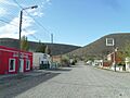
Río Mayo
|
|
|---|---|
.jpg) |
|

Río Mayo
Location in Chubut Province
|
|
| Country | |
| Province | Chubut |
| Department | Río Senguer |
| Elevation | 460 m (1,510 ft) |
| Population
(2010)
|
|
| • Total | 2,791 |
| Time zone | UTC−3 (ART) |
| CPA base |
U9030
|
| Dialing code | +54 2903 |
| Climate | Csc/Dsc |
Río Mayo is a small town in the southwest part of Chubut Province, Argentina. It is located in the Río Senguer Department. This town is an important stop for travelers heading to Chile. It is near two border crossings. One path goes through Lago Blanco to Balmaceda, Chile. The other route is through Aldea Beleiro.
Río Mayo offers important services for visitors. It is also a great place for outdoor activities. You can enjoy sport fishing, horseback riding, and mountain biking here. Hiking is another popular activity in the area.
What is the Climate Like in Río Mayo?
Río Mayo has a very cold climate for most of the year. Winters are long and harsh. The first frosts usually arrive in March or April. Temperatures can drop very low, sometimes reaching -27 degrees Celsius. Even the highest temperatures in winter can be below freezing.
| Climate data for Río Mayo (1991–2020) | |||||||||||||
|---|---|---|---|---|---|---|---|---|---|---|---|---|---|
| Month | Jan | Feb | Mar | Apr | May | Jun | Jul | Aug | Sep | Oct | Nov | Dec | Year |
| Record high °C (°F) | 37.5 (99.5) |
37.0 (98.6) |
35.0 (95.0) |
30.0 (86.0) |
25.0 (77.0) |
19.0 (66.2) |
22.5 (72.5) |
23.5 (74.3) |
26.0 (78.8) |
27.0 (80.6) |
34.0 (93.2) |
36.0 (96.8) |
37.5 (99.5) |
| Mean daily maximum °C (°F) | 23.1 (73.6) |
22.5 (72.5) |
19.6 (67.3) |
15.2 (59.4) |
10.2 (50.4) |
6.5 (43.7) |
6.1 (43.0) |
8.1 (46.6) |
11.7 (53.1) |
15.8 (60.4) |
18.9 (66.0) |
21.4 (70.5) |
14.9 (58.8) |
| Daily mean °C (°F) | 16.6 (61.9) |
15.8 (60.4) |
13.0 (55.4) |
8.4 (47.1) |
4.7 (40.5) |
1.5 (34.7) |
0.9 (33.6) |
2.4 (36.3) |
5.5 (41.9) |
9.4 (48.9) |
12.5 (54.5) |
15.1 (59.2) |
8.8 (47.8) |
| Mean daily minimum °C (°F) | 10.4 (50.7) |
9.8 (49.6) |
7.5 (45.5) |
2.7 (36.9) |
0.1 (32.2) |
−2.7 (27.1) |
−3.5 (25.7) |
−2.1 (28.2) |
0.4 (32.7) |
3.5 (38.3) |
6.4 (43.5) |
8.9 (48.0) |
3.5 (38.3) |
| Record low °C (°F) | −1.0 (30.2) |
0.0 (32.0) |
−6.5 (20.3) |
−10.0 (14.0) |
−18.5 (−1.3) |
−21.0 (−5.8) |
−27.0 (−16.6) |
−19.0 (−2.2) |
−13.0 (8.6) |
−10.0 (14.0) |
−4.5 (23.9) |
−3.0 (26.6) |
−27.0 (−16.6) |
| Average precipitation mm (inches) | 5.8 (0.23) |
6.9 (0.27) |
8.9 (0.35) |
8.8 (0.35) |
22.8 (0.90) |
14.5 (0.57) |
13.1 (0.52) |
15.0 (0.59) |
12.4 (0.49) |
8.2 (0.32) |
5.5 (0.22) |
6.0 (0.24) |
127.9 (5.04) |
| Source: Red Hidrológica Nacional | |||||||||||||
Images for kids
-
A panoramic view of Río Mayo.
See also
 In Spanish: Río Mayo (ciudad) para niños
