Río Negro Department facts for kids
Quick facts for kids
Río Negro Department
|
|||
|---|---|---|---|
|
|||
| Country | |||
| Capital of Department | Fray Bentos | ||
| Area | |||
| • Total | 9,282 km2 (3,584 sq mi) | ||
| Population
(2011 census)
|
|||
| • Total | 54,765 | ||
| • Density | 5.9001/km2 (15.2813/sq mi) | ||
| Demonym(s) | Rio negrense | ||
| Time zone | UTC-3 (UYT) | ||
| ISO 3166 code | UY-RN | ||
Río Negro Department is a region in the northwest of Uruguay. It covers an area of about 9,282 square kilometers (3,584 square miles). Around 54,765 people live here. Its main city and capital is Fray Bentos.
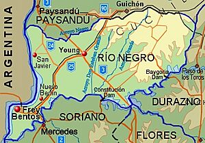
Río Negro shares borders with Paysandú Department to the north and Tacuarembó Department to the east. To the southeast is Durazno Department, and Soriano Department is to the south. The Río Uruguay flows along its western side, forming the border with Argentina.
Contents
History of Río Negro Department
Uruguay was first divided into six departments on January 27, 1816. Later that year, two more departments were created. At that time, the Paysandú Department was much larger. It included all the land north of the Río Negro. This large area covered what are now the departments of Artigas, Rivera, Tacuarembó, Salto, Paysandú, and Río Negro.
On June 17, 1837, Uruguay was divided again. The large northern territory was split into three parts. Even then, the Paysandú Department still included the area of the current Río Negro Department. Río Negro finally became its own separate department in 1868.
Geography of Río Negro
The Río Negro river flows along the southern edge of the department. It forms a natural border with the Durazno Department to the southeast and the Soriano Department to the south. Many smaller streams, called arroyos, flow into the Río Negro throughout the department.
Some of these streams include Arroyo Salsipuedes Grande, which helps form the border with Tacuarembó Department. Other important streams are Arroyo Tres Árboles, Arroyo Grande, and Arroyo Don Esteban Grande.
The Río Negro eventually flows into the Río Uruguay. This happens about 32 kilometers (20 miles) southwest of Fray Bentos. Along the Río Negro, there are two important hydroelectric dams. These are the Rincón de Baygorria Dam and the Constitución Dam (also known as Palmar Dam). They create large reservoirs, but the power plants themselves are in neighboring departments.
A big part of the northern border with Paysandú Department is formed by Arroyo Negro. This stream also flows into the Río Uruguay. Near its mouth, there is a sandy beach called Playa Arroyo Negro. Several sandy islands are found in the Uruguay River near Fray Bentos, between Uruguay and Argentina.
In the northeast of the department, the large Cuchilla de Haedo hill range begins. This range extends northeast, reaching its highest points between the departments of Salto and Rivera. Cerro del Quebracho is a hill in this range. A smaller hill range, the Cuchilla de Navarro, is in the western part of the department. Other hills like Cerro Pelado, Cerro Colorado, and Cerro Malvenir are also found in Río Negro.
Population and People
As of the 2011 census, Río Negro Department had a total population of 54,765 people. This included 27,576 males and 27,189 females. There were also 20,975 households in the department.
Here are some facts about the population in 2010:
- The population grew by about 0.529% each year.
- There were about 15.82 births for every 1,000 people.
- There were about 7.38 deaths for every 1,000 people.
- The average age of people in Río Negro was 31.5 years.
- People in Río Negro lived for about 78.04 years on average. Males lived about 74.78 years, and females lived about 81.05 years.
Main Cities and Towns
The population numbers below are from the 2011 census.
| City / Town | Population |
|---|---|
| Fray Bentos | 22,406 |
| Young | 16,756 |
| Nuevo Berlín | 2,450 |
| San Javier | 1,781 |
Other Towns and Villages
| Town / Village | Population |
|---|---|
| Barrio Anglo | 785 |
| Algorta | 779 |
| Grecco | 598 |
| Colonia Ofir | S/D |
In addition to the people living in cities and towns, the 2011 census showed that 5,212 people lived in rural areas of Río Negro department.
Economy and Industries
Farming is a very important part of the economy in the western part of Río Negro. Farmers grow crops like flax, sunflower, wheat, maize (corn), and other grains. The eastern part of the department has many pastures. These are used for raising sheep and cattle, which also contribute a lot to the economy.
The main industries in Río Negro are often related to agriculture. Wineries, which make wine from grapes, and dairies, which produce milk and cheese, are important examples. The department also has a port in Fray Bentos that can handle river trade.
Tourism is becoming more popular in Río Negro. Many people visit the thermal spas located around the area of Las Cañas.
Botnia Factory
Botnia S.A., a company from Finland, built a large factory in Fray Bentos. This factory produces bleached eucalyptus pulp, which is used to make paper. The company invested about 1 billion US dollars in this project. The factory provides jobs for many people, both directly and indirectly.
There were some concerns about the factory's impact on the environment, especially the Uruguay River. However, a study by the World Bank looked into these concerns.
Notable People from Río Negro
- Guillermo Stirling (born 1937) was a politician from the Colorado Party. He ran for president in 2005.
- Gaston Ramirez (born 1990 in Fray Bentos) is a football (soccer) player. He played for Southampton F.C.
- Vladimir Roslik was a Russian-Uruguayan medical doctor. He was killed during the military rule in Uruguay (1973–1984).
See also
 In Spanish: Departamento de Río Negro para niños
 | James B. Knighten |
 | Azellia White |
 | Willa Brown |


