RAF Down Ampney facts for kids
Quick facts for kids
RAF Down Ampney
|
|||||||||||||||||||
|---|---|---|---|---|---|---|---|---|---|---|---|---|---|---|---|---|---|---|---|

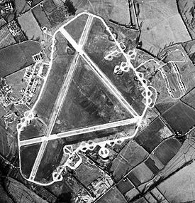
Aerial photograph of Down Ampney airfield, 4 December 1943. The bomb dump is to the right (east) of the airfield, the technical site and barrack sites are to the left.
|
|||||||||||||||||||
| Summary | |||||||||||||||||||
| Owner | Air Ministry | ||||||||||||||||||
| Operator | Royal Air Force | ||||||||||||||||||
| Location | Down Ampney, Gloucestershire | ||||||||||||||||||
| Built | 1943 | ||||||||||||||||||
| In use | 1944-1947 | ||||||||||||||||||
| Elevation AMSL | 270 ft / 82 m | ||||||||||||||||||
| Coordinates | 51°40′01″N 01°50′22″W / 51.66694°N 1.83944°W | ||||||||||||||||||
| Map | |||||||||||||||||||
| Runway | |||||||||||||||||||
|
|||||||||||||||||||
RAF Down Ampney was a special air base used by the Royal Air Force (RAF). It was located near a village called Cricklade in Gloucestershire, England. This base was built in 1943 and started being used in February 1944. It played an important role during World War II.
The base was closed down in February 1947, a few years after the war ended. It was one of many airfields that helped the country during a very busy time.
What Was RAF Down Ampney?
RAF Down Ampney was an airfield, which is like a special airport for military planes. It was part of a group of three important airfields in the area. The other two were RAF Broadwell and RAF Blakehill Farm.
These three airfields worked together. Their main job was to transport, or move, important things by air. This included supplies, equipment, and even people, especially during the war.
Runways at Down Ampney
An airfield needs runways for planes to take off and land. RAF Down Ampney had three main runways. These were long, flat strips of ground made of asphalt, a strong material similar to what roads are made of.
The runways had special numbers to identify them:
- Runway 03/21: This was the longest runway, measuring about 6,000 feet (1,829 meters) long.
- Runway 09/27: This runway was about 4,200 feet (1,280 meters) long.
- Runway 15/33: This runway was also about 4,200 feet (1,280 meters) long.
These runways were essential for the planes that flew in and out of RAF Down Ampney, helping with their important missions during the war.
 | Mary Eliza Mahoney |
 | Susie King Taylor |
 | Ida Gray |
 | Eliza Ann Grier |


