
Rabun Bald facts for kids
Quick facts for kids Rabun Bald |
|
|---|---|

Rabun Bald viewed from Sky Valley, Georgia
|
|
| Highest point | |
| Elevation | 4,696 ft (1,431 m) |
| Prominence | 1,016 ft (310 m) |
| Geography | |

Rabun Bald
Location in Georgia (U.S. state)
|
|
| Parent range | Blue Ridge Mountains |
| Topo map | USGS Rabun Bald |
| Climbing | |
| Easiest route | Bartram Trail |
Rabun Bald is a tall mountain in the U.S. state of Georgia. It stands 4,696 feet (1,431 m) high. This makes it the second-highest mountain peak in Georgia. Only Brasstown Bald, which is 4,784 feet (1,458 m) tall, is higher.
Rabun Bald is located just southeast of Sky Valley, Georgia. It is the tallest mountain in its county. At the very top of Rabun Bald, there is a special tower. This tower lets hikers see amazing views. On a clear day, you can see for more than 100 miles (160 km)!
Hiking to the Top
You can hike to the top of Rabun Bald. The round trip hike is about 5.8 miles (9.3 km) long. This trail is called the Rabun Bald Trail. It connects to a bigger trail system. This system is known as the Bartram Trail. The Bartram Trail goes right over the top of Rabun Bald. It winds through northeast Georgia for about 37 miles (60 km).
Mountain Legends
Native American legends tell stories about Rabun Bald. Some legends say that fire-breathing demon people live on the mountain. Even today, some campers say they hear strange sounds at night. These sounds might be from the mountain's mysterious past.
History of the Tower
Rabun Bald was once home to the first fire tower in its area. This tower helped spot forest fires. A man named Nick Nicholson built it. He was Georgia's first forest ranger. The United States Forest Service used this fire tower. They operated it until the early 1970s.
After the tower was no longer used for fires, a group called the Youth Conservation Corps (YCC) worked on it. They carefully took apart the top part of the tower. This part was a metal room with glass windows. It sat on a strong stone base. The YCC crew left the stone base. They replaced the metal room with a new wooden platform. This platform has railings and is used for observation today.
Images for kids
-
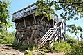
Fire tower on Rabun Bald's summit
-
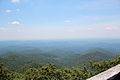
View from Rabun Bald's fire tower, looking south
-
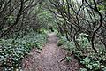
Bartram Trail on Rabun Bald
-
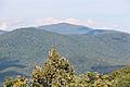
Rabun Bald seen from Black Rock Mountain State Park


.jpg)
