Raheen, County Limerick facts for kids
Quick facts for kids
Raheen
An Ráithín
|
|
|---|---|
|
Suburb
|
|

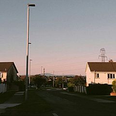
Mulcair Road in the summer
|
|
| Country | Ireland |
| Province | Munster |
| City | Limerick |
| Time zone | UTC+0 (WET) |
| • Summer (DST) | UTC-1 (IST (WEST)) |
| Irish Grid Reference | R550534 |
Raheen (pronounced Rah-heen) is a big neighbourhood, or suburb, located in Limerick, Ireland. Its name, "An Ráithín," means "small ringfort" in Irish. Raheen was first built to help with the growing population of Limerick city. It is a very mixed area, with different types of homes and people. You can find older housing estates and also newer, more expensive areas here.
History of Raheen
The oldest parts of Raheen were built in the 1960s and 1970s. Over the years, Raheen and its nearby area, Dooradoyle, grew a lot. This growth was especially fast during a time called the "Celtic Tiger" in Ireland. The "Celtic Tiger" was a period of rapid economic growth in Ireland from the mid-1990s to the late 2000s.
Raheen became a place where many people from different countries came to live. It has been home to people of Jewish, South Asian, and Chinese backgrounds for a long time. During Ireland's economic boom, many immigrants from Eastern Europe also moved to Raheen.
Before 2014, Raheen was managed by Limerick County Council. This was a different local government from Limerick City Council. In June 2014, the city and county councils joined together. This merger meant that Raheen became part of the city of Limerick.
Raheen's Economy
The economy in Raheen mostly depends on the businesses in the Raheen Business Park. Many international and large companies have offices or factories here. Some of these companies include Regeneron Pharmaceuticals, Analog Devices, and Stryker Corp..
The Dell factory used to be one of the biggest employers in Limerick. However, it closed in January 2009, which was a big challenge for the area. The building where Dell used to be is now used by Regeneron.
The radio station Spin South West is also located in the Raheen Industrial Estate. This industrial estate has two main parts. One entrance is at the Raheen Roundabout, and the other is on the M20 road.
Local Amenities
Raheen shares many useful places with its neighbour, Dooradoyle. These include the Crescent Shopping Centre, which is a large shopping mall. The main campus of University Hospital Limerick is also nearby.
You can find shops, restaurants, and cafes around Raheen and the Father Russell Road area. St. Nessan's Church, a Roman Catholic church, is located in Raheen.
There are several schools in the area. These include St. Paul's National School and St. Nessan's National School. For older students, Crescent Comprehensive College (in Dooradoyle) and Gaelscoil an Raithin are nearby.
Getting Around Raheen
Raheen has good public transport links with three different city bus routes. These are run by Bus Éireann:
- The 301 bus goes between Westbury/Shannon Banks and Father Russell Road, passing through the city centre.
- The 304 bus travels from UL to Raheen/Ballycummin, also going through the city centre.
- The 304A bus connects Monaleen and Raheen. It goes via Colbert Station and avoids the city centre.
The R526 road runs through Raheen and into Limerick City Centre. The N69 national road starts here, connecting Raheen to Tralee in County Kerry. The N18 road links Limerick to Shannon Airport, Ennis, and Galway City.
Raheen also has exits to the M20 and M7 motorways. These motorways connect Limerick city to Cork and Dublin, making it easy to travel to other major cities.
 | Selma Burke |
 | Pauline Powell Burns |
 | Frederick J. Brown |
 | Robert Blackburn |


