Raisin City, California facts for kids
Quick facts for kids
Raisin City
|
|
|---|---|

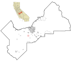
Location in Fresno County and the state of California
|
|
| Country | |
| State | |
| County | Fresno |
| Area | |
| • Total | 0.760 sq mi (1.967 km2) |
| • Land | 0.760 sq mi (1.967 km2) |
| • Water | 0 sq mi (0 km2) 0% |
| Elevation | 236 ft (72 m) |
| Population
(2020)
|
|
| • Total | 303 |
| • Density | 398.7/sq mi (154.04/km2) |
| Time zone | UTC-8 (PST) |
| • Summer (DST) | UTC-7 (PDT) |
| ZIP code |
93652
|
| Area code(s) | 559 |
| FIPS code | 06-59290 |
| GNIS feature IDs | 1659457, 2409124 |
Raisin City is a small community in Fresno County, California, United States. It used to be called "Raisin." This area is known as a census-designated place (CDP). This means it's a community that looks like a town but isn't officially governed as one.
In 2020, about 303 people lived in Raisin City. Back in 2010, the population was 380, and in 2000, it was 165. This shows the population has changed quite a bit over the years. Raisin City is located about 13 miles (21 km) south-southwest of downtown Fresno. It sits at an elevation of 236 feet (72 meters) above sea level.
Contents
Understanding Raisin City's Location
Raisin City is located in the central part of California. It is part of Fresno County, which is a large county in the state. The area is mostly flat land.
How Big is Raisin City?
According to the United States Census Bureau, Raisin City covers a total area of about 0.8 square miles (2.1 square kilometers). All of this area is land, with no large bodies of water like lakes or rivers within its borders.
A Glimpse into Raisin City's Past
Raisin City has a simple history. The first post office in the area was opened in 1907. This was an important step for the community. It helped people send and receive mail.
Who Lives in Raisin City?
Learning about the people who live in a place is called demographics. This section shares information about the population of Raisin City.
Population Details from 2010
In 2010, there were 380 people living in Raisin City. This means there were about 500 people for every square mile. Most of the people living here were from diverse backgrounds. About 81% of the population identified as Hispanic or Latino.
All 380 people lived in homes with their families or housemates. There were 81 households in total. Many of these households, about 59%, had children under 18 living there. The average household had about 4.69 people.
The population was quite young. About 36% of the people were under 18 years old. The median age was 24.8 years. This means half the people were younger than 24.8, and half were older.
There were 91 housing units in Raisin City. About half of these homes were owned by the people living in them. The other half were rented.
Population Details from 2000
In 2000, Raisin City had a smaller population of 165 people. The population density was about 214 people per square mile. Similar to 2010, about 60% of the population was Hispanic or Latino.
There were 42 households in 2000. About 47% of these households had children under 18. The average household size was 3.93 people. The median age in 2000 was 30 years.
The average income for a household was about $24,167. For families, it was about $23,958. Some families and people were living below the poverty line. This included about 47% of those under 18 years old.
See also
 In Spanish: Raisin City para niños
 | Lonnie Johnson |
 | Granville Woods |
 | Lewis Howard Latimer |
 | James West |


