Rampart Lakes facts for kids
Quick facts for kids Rampart Lakes |
|
|---|---|

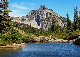
Hibox Mountain from Rampart Lakes area
|
|
| Location | Kittitas County, Washington, United States |
| Coordinates | 47°24′57″N 121°20′26″W / 47.4157129°N 121.3404298°W |
| Basin countries | United States |
| Surface area | 6.3 acres (0.025 km2) |
| Surface elevation | 5,082 ft (1,549 m) |
The Rampart Lakes are a group of connected lakes. You can find them on the southern side of Alta Mountain. This area is in Kittitas County, Washington.
These lakes are a great spot for outdoor fun. Many people visit for hiking, swimming, and fishing. You can often catch a type of fish called cutthroat trout here. If you plan to explore the nearby Klonaqua Lakes area, you will need a special permit. This permit is from the Alpine Lake Wilderness.
Weather at Rampart Lakes
The Rampart Lakes area has a cool climate. It is called a hemiboreal climate. This means it has cold, snowy winters and mild summers.
The average temperature around the lakes is about 4° Celsius (39° Fahrenheit). August is usually the warmest month. The average temperature then is 17° Celsius (63° Fahrenheit). January is the coldest month. Temperatures can drop to an average of −8° Celsius (18° Fahrenheit).
The amount of rain and snow is similar to other lakes in the Alpine Lakes Wilderness. January is the wettest month. It gets about 396 millimeters (15.6 inches) of rain. July is the driest month. It only gets about 38 millimeters (1.5 inches) of rain.
How to Reach Rampart Lakes
The Rampart Lakes are about one mile west of Rachel Lake. You can get to them by extending the Rachel Lake Trail #1313.
The trail starts by following Box Canyon Creek. The trailhead is located at Forest Road 4930. This road is on the western shores of Little Kachess Lake. This spot is about 20 miles east of The Summit at Snoqualmie. You can reach it from Interstate 90.


