
Alta Mountain facts for kids
Quick facts for kids Alta Mountain |
|
|---|---|
.jpg)
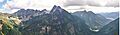
Alta Mountain seen from Interstate 90 at Hyak
|
|
| Highest point | |
| Elevation | 6,240 ft (1,900 m) |
| Prominence | 520 ft (160 m) |
| Isolation | 1.6 mi (2.6 km) |
| Parent peak | Hibox Mountain (6,330 ft) |
| Geography | |

Alta Mountain
Location in Washington (state)

Alta Mountain
Location in the United States
|
|
| Location | Kittitas County, Washington, U.S. |
| Parent range | Cascade Range |
| Topo map | USGS Chikamin Peak |
| Climbing | |
| Easiest route | Scrambling (class 2) South Ridge |
Alta Mountain is a tall mountain in Kittitas County, Washington state. It stands about 6,240 feet (1,902 meters) high. This mountain is part of the Alpine Lakes Wilderness. This wild area is found within the larger Cascade Range mountains.
Alta Mountain is on land managed by the Wenatchee National Forest. Water from rain and melting snow flows off the mountain. This water then drains into smaller streams that feed the Yakima River.
Contents
Mountain Weather
Alta Mountain is in a "marine west coast" climate zone. This means it gets a lot of moisture from the nearby Pacific Ocean. Most weather systems come from the Pacific and move northeast.
How Mountains Affect Weather
When these weather systems hit the Cascade Mountains, they are forced to rise. As the air goes up, it cools down. This cooling causes the moisture in the air to turn into rain or snow. This process is called orographic lift.
Because of this, the western side of the Cascade Mountains gets a lot of rain and snow. This is especially true during the winter months.
Seasonal Weather Patterns
In winter, the weather is often cloudy. But in summer, high-pressure systems over the Pacific Ocean bring clear skies. This means there is often little or no cloud cover during summer.
The snow in this area tends to be wet and heavy. This can make the risk of avalanches higher. The best time to visit or climb Alta Mountain is usually from July through September. During these months, the weather is most favorable.
Mountain Geology
The Alpine Lakes Wilderness has very rugged land. It features sharp peaks, long ridges, and deep valleys carved by glaciers. You can also see tall granite walls. This area is home to over 700 mountain lakes.
How Mountains Formed
The amazing shapes of the Cascade Mountains were created over millions of years. This happened because of big geological events. These events caused huge changes in elevation. These changes also led to different climates in various areas. These climate differences then created different types of plant life.
The Cascade Mountains started forming millions of years ago. This was during the late Eocene Epoch. At that time, the North American Plate was slowly moving over the Pacific Plate. This movement caused many volcanic eruptions. Also, small pieces of the Earth's crust, called terranes, helped form the North Cascades. This happened about 50 million years ago.
Impact of Glaciers
During the Pleistocene period, which was over two million years ago, glaciers covered the land. These huge ice sheets moved forward and then melted back many times. As they moved, they scraped away the landscape. They left behind piles of rock and debris.
The last glaciers in the Alpine Lakes area started melting about 14,000 years ago. They had moved north of the Canada–US border by 10,000 years ago. The river valleys in this area have a "U" shape. This shape was created by these recent glaciers.
The tall peaks and deep valleys of the Alpine Lakes Wilderness were formed by two main things. These are the land pushing upwards (uplift) and cracks in the Earth's crust (faulting). These processes worked together with the glaciers.
Images for kids
-
Alta Mountain from the north
-

Alta Mountain and Rampart Lakes

