
Hibox Mountain facts for kids
Quick facts for kids Hibox Mountain |
|
|---|---|

Hibox Mountain from Rampart Lakes area
|
|
| Highest point | |
| Elevation | 6,547 ft (1,996 m) |
| Prominence | 1,027 ft (313 m) |
| Isolation | 1.73 mi (2.78 km) |
| Parent peak | Chikamin Peak (7,020 ft) |
| Geography | |

Hibox Mountain
Location in Washington (state)

Hibox Mountain
Location in the United States
|
|
| Location | Kittitas County Washington, U.S. |
| Parent range | Cascade Range |
| Topo map | USGS Chikamin Peak |
| Climbing | |
| Easiest route | Scrambling |
Hibox Mountain is a mountain peak in Washington state. It stands about 6,547 feet (1,996 meters) tall. You can find it in Kittitas County, within the beautiful Cascade Range.
This mountain is part of the Alpine Lakes Wilderness. This is a special area managed by the Okanogan-Wenatchee National Forest. The name "Hibox" is a mix of "high" and "Box Ridge." This is because it's the highest point on Box Ridge.
Hibox Mountain is about five miles east of Snoqualmie Pass. Another mountain, Alta Mountain, is just 1.5 miles to its west-northwest. Water from Hibox Mountain flows into Box Canyon Creek and Mineral Creek. Both of these creeks eventually reach Kachess Lake.
Contents
Weather Around Hibox Mountain
Hibox Mountain is in a place with a "marine west coast" climate. This means it gets a lot of weather from the ocean. Most weather systems start over the Pacific Ocean. They then travel northeast towards the Cascade Mountains.
How Mountains Affect Weather
When these weather systems hit the tall Cascade Mountains, they are forced to rise. This process is called orographic lift. As the air rises, it cools down. This causes the moisture in the air to turn into rain or snow. Because of this, the Cascade Mountains get a lot of rain and snow, especially in winter.
During winter, the weather is often cloudy. But in summer, high pressure systems over the Pacific Ocean bring clear skies. The snow here tends to be wet and heavy because of the ocean's influence. This can create a danger of avalanches.
How Hibox Mountain Was Formed
The Alpine Lakes Wilderness has very rugged land. It has sharp peaks, long ridges, deep valleys carved by glaciers, and tall granite walls. There are also more than 700 mountain lakes in this area.
Ancient Earth Events
Long, long ago, huge geological events shaped the land. These events created the different heights and climates you see in the Cascade Range today. The land here ranges from about 1,000 feet (300 meters) high to over 9,000 feet (2,700 meters) on Mount Stuart.
The Cascade Mountains started forming millions of years ago. This was during a time called the late Eocene Epoch. The North American Plate (a huge piece of Earth's crust) was moving over the Pacific Plate. This caused many volcanic eruptions. Also, small pieces of Earth's crust, called terranes, helped build the North Cascades about 50 million years ago.
Ice Age and Glaciers
About two million years ago, during the Pleistocene period (also known as the Ice Age), huge sheets of ice called glaciers moved across the land. They moved forward and backward many times. As they moved, they scraped and shaped the landscape. They left behind piles of rock and debris.
The last time glaciers retreated from the Alpine Lakes area was about 14,000 years ago. By 10,000 years ago, they had moved north of the Canada–US border. The U-shaped valleys you see in the rivers were formed by these glaciers. The mountains became tall and the valleys became deep because of a mix of uplift (when land pushes up) and faulting (cracks in the Earth's crust), along with the action of glaciers.
Images for kids
-
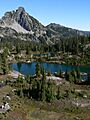
Lila Lake with Hibox Mountain in the background
-
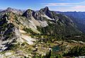
Hibox Mountain


