Mount Stuart facts for kids
Quick facts for kids Mount Stuart |
|
|---|---|

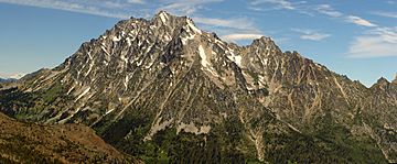
Mount Stuart from the south.
|
|
| Highest point | |
| Elevation | 9,415 ft (2,870 m) NGVD 29 |
| Prominence | 5,354 ft (1,632 m) |
| Listing |
|
| Geography | |
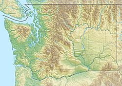
| Location | Chelan County, Washington, U.S. |
| Parent range | Stuart Range, Cascade Range |
| Topo map | USGS Mount Stuart |
| Geology | |
| Age of rock | Late Cretaceous |
| Mountain type | Granite |
| Climbing | |
| First ascent | 1873 by A. McPherson and party |
| Easiest route | Major scramble |
Mount Stuart is a tall mountain located in the Cascade Range in Washington, a state in the United States. It is the second highest non-volcanic peak in Washington, meaning it's not a volcano. Only Bonanza Peak is taller among non-volcanic mountains. Overall, Mount Stuart is the tenth-highest peak in the state.
This impressive mountain is the tallest point in the Stuart Range. You can find it in the middle part of the Washington Cascades. It sits south of Stevens Pass and east of Snoqualmie Pass, within a beautiful natural area called the Alpine Lakes Wilderness.
Contents
How Mount Stuart Got Its Name
Mount Stuart was named by a man named George B. McClellan in September 1853. He named it after his good friend, Captain Jas. [Jimmie] Stuart. Captain Stuart was a brave soldier who had passed away a few years earlier in 1851. He died from an arrow wound after a fight with Native Americans in Oregon.
What Makes Mount Stuart Special?
Mount Stuart is known for how steeply its sides rise from the ground below. For example, its south face climbs about 5,000 feet (1,524 meters) in just two miles (3.2 kilometers) horizontally. The northeast and northwest sides are also very steep.
Because Mount Stuart stands out from other nearby peaks, it has a high topographic prominence. This means it rises significantly above the land around it. Its prominence is 5,354 feet (1,632 meters), making it the sixth most prominent peak in Washington state.
The mountain is made of a type of rock called Granite. This granite is rugged because it has many cracks, called joints. On the northern slopes of Mount Stuart, you can find three glaciers. These are the Stuart, Ice Cliff, and Sherpa Glaciers. They are found from west to east.
Who First Climbed Mount Stuart?
It's not completely clear who was the very first person to reach the top of Mount Stuart. One story comes from Claude Rusk, who heard that someone found a stick on the summit with the name "Angus McPherson—1873" carved into it. This suggests Angus McPherson might have been an early climber.
Another idea comes from A. H. Sylvester, who climbed the mountain in 1897 and 1899. He believed the first ascent was made by Frank Tweedy and Richard Goode. They climbed Mount Stuart on August 5, 1883, and then again two days later. However, they didn't report finding any signs of earlier climbers. Since the easiest way up the mountain isn't too difficult, it's also possible that Native Americans climbed it even earlier.
Popular Climbing Routes
The most common way to climb Mount Stuart is called the Cascadian Couloir. This route goes up the southeast side of the mountain. It leads to a "false summit" (a peak that looks like the top but isn't quite) and then follows a short ridge to the true summit. This route involves scrambling, which is a mix of hiking and easy climbing, and sometimes includes steep snow.
For more experienced climbers, there are much harder routes on the complex north face and other parts of the mountain. These routes require special climbing skills and equipment.
 | Bayard Rustin |
 | Jeannette Carter |
 | Jeremiah A. Brown |


